Wirscheid | |
|---|---|
| Coordinates: 50°28′41″N 7°40′2″E / 50.47806°N 7.66722°E | |
| Country | Germany |
| State | Rhineland-Palatinate |
| District | Westerwaldkreis |
| Municipal assoc. | Ransbach-Baumbach |
| Government | |
| • Mayor | Bernhard Wirz |
| Area | |
| • Total | 2.68 km2 (1.03 sq mi) |
| Elevation | 293 m (961 ft) |
| Population (2019-12-31)[1] | |
| • Total | 329 |
| • Density | 120/km2 (320/sq mi) |
| Time zone | UTC+01:00 (CET) |
| • Summer (DST) | UTC+02:00 (CEST) |
| Postal codes | 56237 |
| Dialling codes | 02601 |
| Vehicle registration | WW |
| Website | www.wirscheid.de |
Wirscheid is an Ortsgemeinde – a community belonging to a Verbandsgemeinde – in the Westerwaldkreis in Rhineland-Palatinate, Germany.
Geography
Location
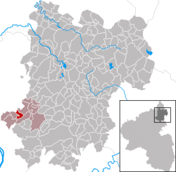
The community lies in the Westerwald between Koblenz and Altenkirchen in the Kannenbäckerland (“Jug Bakers’ Land”, a small region known for its ceramics industry). Wirscheid belongs to the Verbandsgemeinde of Ransbach-Baumbach, a kind of collective municipality. Its seat is in the like-named town.
History
In 1547, Wirscheid had its first mention in a historical document as Wersched.
Politics
Community council
The council is made up of 11 council members, including the extraofficial mayor (Bürgermeister), who were elected in a municipal election on 13 June 2004.
| Grüne | WG Wirz | Total | |
| 2004 | 2 | 8 | 10 seats |
Economy and infrastructure
Transport
Autobahn A 48 with its Höhr-Grenzhausen interchange (AS 12) lies 6 km away. The nearest InterCityExpress stop is the railway station at Montabaur on the Cologne-Frankfurt high-speed rail line.
References
- ^ "Bevölkerungsstand 2019, Kreise, Gemeinden, Verbandsgemeinden". Statistisches Landesamt Rheinland-Pfalz (in German). 2020.
External links
- Wirscheid (in German)


