Wikipedia

Bundesautobahn 48

A48 shield}}

A48
Bundesautobahn 48
Route information
Length79 km (49 mi)
Major junctions
West endBundesautobahn 1 number.svg A 1 in Steiningen
East endBundesautobahn 3 number.svg A 3 in Dernbach
Location
StatesRhineland-Palatinate
Highway system
  • Roads in Germany
Bundesautobahn 46 number.svg A46Bundesautobahn 49 number.svg A49

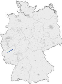
Bundesautobahn 48 (translates from German as Federal Motorway 48, short form Autobahn 48, abbreviated as BAB 48 or A 48) is an autobahn in western Germany. From the junction with the A 1 it connects to the A 3 and A 61 near Koblenz and is fully part of European route E 44.

Exit list

AB-Kreuz-blau.svg (1) Vulkaneifel 3-way interchange A1 E44
Zeichen 314-50 - Parkplatz, StVO 2013.svg Steininger Höhe/Bierscheid parking area
AB-AS-blau.svg (2) Ulmen B259
Zeichen 314-50 - Parkplatz, StVO 2013.svg Uersfeld parking area Pfeil unten.svg
Zeichen 314-50 - Parkplatz, StVO 2013.svg Höchstberg parking area Pfeil oben.svg
AB-AS-blau.svg (3) Laubach
Zeichen 314-50 - Parkplatz, StVO 2013.svg Martental/Good viewpoint parking area
AB-AS-blau.svg (4) Kaisersesch
Zeichen 314-50 - Parkplatz, StVO 2013.svg Belzweide/Herberkaul parking area
AB-AS-blau.svg (5) Kaifenheim
AB-Brücke.svg Elz Viaduct 380 m
AB-Tank.svg AB-Rast.svg Services Elztal
AB-AS-blau.svg (6) Mayen B262
Zeichen 314-50 - Parkplatz, StVO 2013.svg Rotendall parking area Pfeil unten.svg
AB-AS-blau.svg (7) Polch
Zeichen 314-50 - Parkplatz, StVO 2013.svg Mammutgrube parking area Pfeil oben.svg
Zeichen 314-50 - Parkplatz, StVO 2013.svg Schnackenborn/Münsterer Höhe parking area
AB-AS-blau.svg (8) Ochtendung
Zeichen 314-50 - Parkplatz, StVO 2013.svg Goloring/Karmelenberg parking area
AB-Kreuz-blau.svg (9) Koblenz 4-way interchange A61 E31
Zeichen 314-50 - Parkplatz, StVO 2013.svg Schießer Weg/Erdkaul parking area
AB-AS-blau.svg (10) Koblenz-Nord B9
AB-Brücke.svg Bendorf Bridge 1029 m
AB-AS-blau.svg (11) Bendorf/Neuwied B42
Zeichen 314-50 - Parkplatz, StVO 2013.svg Auf der Zeg parking area Pfeil unten.svg
Zeichen 314-50 - Parkplatz, StVO 2013.svg Nonnenberg parking area
AB-Tank.svg AB-Rast.svg Services Grenzau Pfeil unten.svg
AB-AS-blau.svg (12) Höhr-Grenzhausen
AB-Brücke.svg Brexbach Viaduct 260 m
Zeichen 314-50 - Parkplatz, StVO 2013.svg Seelbachwiese/Mühlholz parking area
Zeichen 314-50 - Parkplatz, StVO 2013.svg Kannebäckerland parking area Pfeil oben.svg
AB-Kreuz-blau.svg (13) Dernbach 3-way interchange A3 E35 E44

External links

This article is copied from an article on Wikipedia® - the free encyclopedia created and edited by its online user community. The text was not checked or edited by anyone on our staff. Although the vast majority of Wikipedia® encyclopedia articles provide accurate and timely information, please do not assume the accuracy of any particular article. This article is distributed under the terms of GNU Free Documentation License.

Copyright © 2003-2025 Farlex, Inc Disclaimer
All content on this website, including dictionary, thesaurus, literature, geography, and other reference data is for informational purposes only. This information should not be considered complete, up to date, and is not intended to be used in place of a visit, consultation, or advice of a legal, medical, or any other professional.