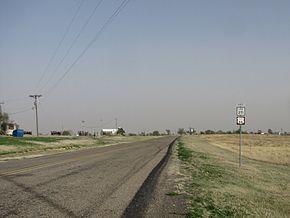
| State Highway Loop 271 | ||||
|---|---|---|---|---|
| Route information | ||||
| Maintained by TxDOT | ||||
| Length | 1.335 mi[1] (2.148 km) | |||
| Existed | 1953–present | |||
| Major junctions | ||||
| West end | ||||
| East end | ||||
| Highway system | ||||
| ||||

Loop 271 is a state highway loop in Alanreed, Texas.[1]
Route description
Loop 271 begins at the end of the ramp for eastbound Interstate 40's exit #135; traffic may also turn on to the eastbound frontage road. The route travels along 3rd Avenue, and intersects FM 291 in the center of Alanreed. The highways share a brief concurrency before FM 291 turns to the south. Loop 271 ends at I-40, where eastbound traffic can either enter the freeway eastbound or default onto the eastbound frontage road.[2]
History
Loop 271 was designated on July 28, 1953. It is an older alignment of US 66, which was rerouted north of the town that year.[1] The route is signed with Historic US 66 route markers. When Interstate 40 supplanted US 66 around Alanreed and the endpoints were converted to incomplete interchanges, the route description was not changed; as a result, the certified length is thus longer than the actual current length.[1]
Major intersections
The entire route is in Alanreed, Gray County.
| mi[3] | km | Destinations | Notes | ||
|---|---|---|---|---|---|
| 0.0 | 0.0 | Western terminus; eastbound exit only | |||
| 0.4 | 0.64 | West end of FM 291 concurrency | |||
| 1.0 | 1.6 | East end of FM 291 concurrency | |||
| 1.1 | 1.8 | Eastern terminus; eastbound entrance only | |||
| 1.000 mi = 1.609 km; 1.000 km = 0.621 mi | |||||
References
- ^ a b c d Transportation Planning and Programming Division (n.d.). "State Highway Loop No. 271". Highway Designation Files. Texas Department of Transportation. Retrieved June 18, 2010.
- ^ Transportation Planning and Programming Division (2014). Texas County Mapbook (PDF) (Map) (2014 ed.). 1:120,000. Texas Department of Transportation. p. 172. Retrieved December 6, 2014.
- ^ Google (April 18, 2011). "Overview map of Texas State Highway Loop 271 Distances Between Interchanges" (Map). Google Maps. Google. Retrieved April 18, 2011.
