| State Highway 153 | ||||
|---|---|---|---|---|
 | ||||
| Route information | ||||
| Maintained by TxDOT | ||||
| Length | 70.89 mi[1] (114.09 km) | |||
| Existed | 1988–present | |||
| Major junctions | ||||
| South end | ||||
| ||||
| North end | ||||
| Location | ||||
| Counties | Coleman, Runnels, Taylor, Nolan | |||
| Highway system | ||||
| ||||
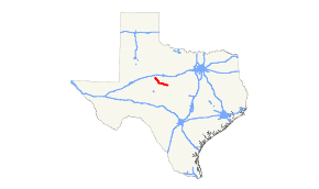
State Highway 153 (SH 153) is a highway in the U.S. State of Texas that runs from Coleman northwest to a junction south of Sweetwater.
History
SH 153 was originally designated on March 19, 1930 along a route from Valley Mills to Temple as a renumbering of SH 36A. This route was rerouted so that its south end was at Belton later. This route was cancelled on June 15, 1935.[2] The road was restored on October 22, 1935, but as a lateral road, which the section south of McGregor became SH 317 on May 23, 1939, and the remainder became FM 56 on May 19, 1942 (this section became part of SH 317 in 1947).[3] The current route was designated on May 16, 1988, replacing FM 53.[1][4]
Major intersections
| County | Location | mi | km | Destinations | Notes |
|---|---|---|---|---|---|
| Coleman | Coleman | Southern terminus | |||
| South end of SH 206 overlap | |||||
| North end of SH 206 overlap | |||||
| | |||||
| Glen Cove | |||||
| Runnels | | ||||
| | |||||
| | |||||
| | |||||
| Winters | |||||
| | |||||
| | |||||
| | |||||
| | |||||
| | |||||
| Taylor | | Interchange | |||
| Nolan | | ||||
| | |||||
| | Northern terminus | ||||
| 1.000 mi = 1.609 km; 1.000 km = 0.621 mi | |||||
References
- ^ a b Transportation Planning and Programming Division (n.d.). "State Highway No. 153". Highway Designation Files. Texas Department of Transportation. Retrieved October 30, 2015.
- ^ (PDF) https://publicdocs.txdot.gov/minord/MinuteOrderDocLib/003673871.pdf.
- ^ (PDF) https://publicdocs.txdot.gov/minord/MinuteOrderDocLib/003673876.pdf.
- ^ Transportation Planning and Programming Division (n.d.). "Farm to Market Road No. 53". Highway Designation Files. Texas Department of Transportation. Retrieved October 3, 2017.
