 | |
| Overview | |
|---|---|
| Headquarters | Cincinnati, OH |
| Locale | Cincinnati, OH |
| Dates of operation | 1872–1948 |
| Technical | |
| Track gauge | 4 ft 8 1&fras1;2 in (1,435 mm) standard gauge |
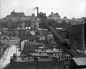
The Mount Adams Incline was a funicular, or inclined railway, located in the Cincinnati neighborhood of Mount Adams. Completed in 1872, it was the longest-running of the city's five inclines, closing in 1948.[1] It has since been demolished.[2]
The incline was 945 feet (288 m) long and carried streetcars and automobiles.[3]
See also
- Funicular railway
- List of funicular railways
References
- ^ Schrage, Robert (Jul 1, 2006). "Along the Ohio River: Cincinnati to Louisville". Arcadia Publishing. p. 16. Retrieved 2013-05-27.
- ^ Cooper, Catherine (Apr 1984). "So Inclined: Scaling the Heights In Style". Cincinnati Magazine. p. 96. Retrieved 2013-05-05.
- ^ Federal Writers' Project (1943). "Cincinnati, a Guide to the Queen City and Its Neighbors". p. 257. Retrieved 2013-05-04.
External links
