| Battlesbridge | |
|---|---|
) The bridge and antiques centre | |
) Battlesbridge Location within Essex | |
| OS grid reference | TQ775945 |
| Civil parish | |
| District |
|
| Shire county | |
| Region | |
| Country | England |
| Sovereign state | United Kingdom |
| Post town | Wickford |
| Postcode district | SS11 |
| Dialling code | 01268 |
| Police | Essex |
| Fire | Essex |
| Ambulance | East of England |
| UK Parliament | |
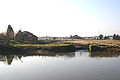
Battlesbridge is a village in Essex, England in the civil parish of Rettendon. It is a suburb of the town Wickford and falls under the postal codes used in Wickford. The village straddles the tidal River Crouch approximately 14 km (9 miles) south-southeast of Chelmsford.[1]
The bridge over the River Crouch was kept in repair from the earliest days by the Bataille family, hence the name of the hamlet. Today it is home to a number of antiques centres, one of which is a former mill.[2]
Battlesbridge is a conservation area which was jointly designated by Chelmsford Borough Council (north side of the river) and Rochford District Council (south side of the river) in February 1992 and March 1992 respectively.
The Tidal Gates were replaced in 2008. The new gates weighing 19 tonnes, were constructed using pine beams and metal sluices. The basic work was completed by Roy Hart and his son Justin. Woodham Ferrers engineers the Keeble brothers, assisted with some of the more specialised milling.
The design and draughtsmanship for the working drawings was entirely the work of Roy. [3]
The village is served by Battlesbridge railway station on the Crouch Valley Line.
Classic Car and Motorbike shows are held here each year.
The Battlesbridge Rural Theatre puts on shows in aid of Charities.
History
The old timber bridge was replaced by an iron structure in 1856, but this was destroyed when it was struck by a large steam traction engine, and the present structure was erected in 1872.[4]
This needed to have steel supports to prevent it from collapsing.
Images
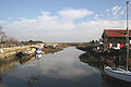
The Crouch
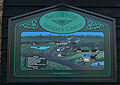
Local information sign
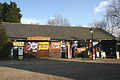
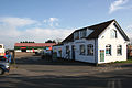
Motorcycle Museum
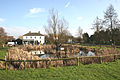
The Village Pond
The Tidal Gates
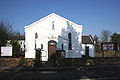
Battlesbridge Free Church
Battlesbridge Harbour
)
)
)
)
)
)
)
Public Houses
| The Barge Inn | The Hawk |
|---|---|
) | ) |
References
- ^ Ordnance Survey, Explorer 1:25,000 map, sheet 175
- ^ "Archived copy". Archived from the original on 21 May 2006. Retrieved 22 January 2009.
- ^ http://www.echo-news.co.uk/news/2257547.a_heart_to_hart_with_the_river/?act=login
- ^ http://www.rettendonandbattlesbridge.org.uk/Battlesbridge_New_pdf-web.pdf Conservation Area management plan