Southend-on-Sea | |
|---|---|
) SS | |
| Coordinates: 51°33′47″N 0°35′53″E / 51.563°N 0.598°E | |
| Country | United Kingdom |
| Postcode area | SS |
| Postcode area name | Southend-on-Sea |
| Post towns | 11 |
| Postcode districts | 19 |
| Postcode sectors | 81 |
| Postcodes (live) | 11,891 |
| Postcodes (total) | 17,265 |
| Statistics as at May 2020[1] | |
The SS postcode area, also known as the Southend-on-Sea postcode area,[2] is a group of seventeen postcode districts in England, within eleven post towns. These cover south-east Essex, including Southend-on-Sea, Basildon, Benfleet, Canvey Island, Hockley, Leigh-on-Sea, Rayleigh, Rochford, Stanford-le-Hope, Westcliff-on-Sea and Wickford.
Coverage
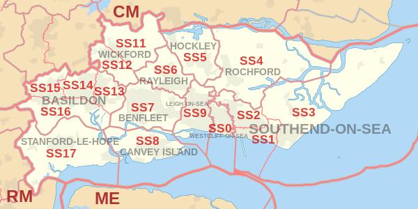
The approximate coverage of the postcode districts:
| Postcode district | Post town | Coverage | Local authority area(s) |
|---|---|---|---|
| SS0 | WESTCLIFF-ON-SEA | Westcliff-on-Sea, Chalkwell | Southend-on-Sea |
| SS1 | WESTCLIFF-ON-SEA | PO Boxes[3] | non-geographic |
| SS1 | SOUTHEND-ON-SEA | Southend-on-Sea, Thorpe Bay | Southend-on-Sea |
| SS2 | SOUTHEND-ON-SEA | Southend-on-Sea, Prittlewell, Southchurch | Southend-on-Sea |
| SS3 | SOUTHEND-ON-SEA | Shoeburyness, Great Wakering, Little Wakering, Barling | Rochford, Southend-on-Sea |
| SS4 | ROCHFORD | Rochford, Ashingdon, Canewdon, Stambridge, Paglesham | Rochford |
| SS5 | HOCKLEY | Hockley, Hullbridge, Hawkwell | Rochford |
| SS6 | RAYLEIGH | Rayleigh | Rochford |
| SS7 | BENFLEET | Hadleigh, South Benfleet, Thundersley | Castle Point |
| SS8 | CANVEY ISLAND | Canvey Island | Castle Point |
| SS9 | LEIGH-ON-SEA | Eastwood, Leigh-on-Sea | Southend-on-Sea |
| SS11 | WICKFORD | Wickford | Basildon, Chelmsford, Rochford |
| SS12 | WICKFORD | Wickford, North Benfleet | Basildon |
| SS13 | BASILDON | Pitsea | Basildon |
| SS14 | BASILDON | Basildon | Basildon |
| SS15 | BASILDON | Laindon | Basildon |
| SS16 | BASILDON | Langdon Hills | Basildon |
| SS17 | STANFORD-LE-HOPE | Stanford-le-Hope, Corringham, Horndon-on-the-Hill | Thurrock |
| SS22 | SOUTHEND-ON-SEA | International Masters Publishers[3] | non-geographic |
| SS99 | SOUTHEND-ON-SEA | HM Revenue and Customs (VAT),[3] First Data[3] | non-geographic |
Map
See also
References
- ^ "ONS Postcode Directory Version Notes" (ZIP). National Statistics Postcode Products. Office for National Statistics. May 2020. Table 2. Retrieved 19 June 2020. Coordinates from mean of unit postcode points, "Code-Point Open". OS OpenData. Ordnance Survey. February 2012. Retrieved 21 April 2012.
- ^ Royal Mail, Address Management Guide, (2004)
- ^ a b c d "Non Geographic Codes" (PDF). Royal Mail Address Management Unit. July 2012. Archived from the original (PDF) on 16 September 2012. Retrieved 14 January 2013.