Loker | |
|---|---|
) | |
| Coordinates: 50°46′53″N 2°46′25″E / 50.78139°N 2.77361°E | |
| Country | Belgium |
| Province | |
| Municipality | Heuvelland |
| Area | |
| • Total | 6.80 km2 (2.63 sq mi) |
| Population (2001) | |
| • Total | 572 |
| Source: NIS | |
| Postal code | 8958 |
Loker (also spelt Locre [1]) is a small village in the Belgian province of West Flanders, and a part ("deelgemeente") of the municipality of Heuvelland.
For the major part of World War I, the city was controlled by the Allied Powers. A field hospital was located there and multiple war graves can also be found.[1]
Gallery
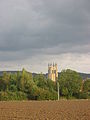
Saint Peter Church
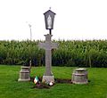
Grave of Major Willie Redmond, killed during the Battle of Messines (1917)

Entrance to the Locre No.10 Cemetery
)
)
)
References
- ^ a b "Locre (Loker) Hospice Cemetery, Belgium". Remembering the Fallen. Retrieved 27 December 2017.