| ||||
|---|---|---|---|---|
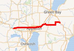 WIS-96 highlighted in red | ||||
| Route information | ||||
| Maintained by WisDOT | ||||
| Length | 55.94 mi[1] (90.03 km) | |||
| Major junctions | ||||
| West end | ||||
| ||||
| East end | ||||
| Location | ||||
| Counties | Waupaca, Outagamie, Brown | |||
| Highway system | ||||
| ||||
)
State Trunk Highway 96 (often called Highway 96, STH-96 or WIS 96) is a state highway in the U.S. state of Wisconsin. It runs east–west in east-central Wisconsin from near Fremont to Denmark.
Major intersections
| County | Location | mi[1] | km | Destinations | Notes |
|---|---|---|---|---|---|
| Waupaca | Town of Fremont | 0.00 | 0.00 | Southern end of WIS 110 concurrency; roadway continues southward as CTH-II | |
| 0.73 | 1.17 | Northern end of WIS 110 concurrency | |||
| Town of Caledonia | 4.85 | 7.81 | |||
| Waupaca–Outagamie county line | Caledonia–Dale town line | 6.36 | 10.24 | ||
| Outagamie | Town of Dale | 9.38 | 15.10 | ||
| 11.40 | 18.35 | ||||
| Town of Greenville | 16.40 | 26.39 | |||
| 17.91 | 28.82 | ||||
| Town of Grand Chute | 19.94– 19.96 | 32.09– 32.12 | |||
| 20.43 | 32.88 | ||||
| Appleton | 22.43 | 36.10 | |||
| Little Chute | 27.40 | 44.10 | |||
| Kaukauna | 30.12 | 48.47 | Western end of WIS 55 concurrency | ||
| 30.56 | 49.18 | Eastern end of WIS 55 concurrency | |||
| Town of Kaukauna | 33.02 | 53.14 | |||
| Outagamie–Brown county line | Kaukauna–Wrightstown village line | 34.86 | 56.10 | ||
| Brown | Wrightstown | 36.20 | 58.26 | ||
| 36.43 | 58.63 | ||||
| 40.16 | 64.63 | ||||
| 41.43 | 66.68 | ||||
| Town of Morrison | 44.47 | 71.57 | |||
| 47.43 | 76.33 | ||||
| Town of New Denmark | 53.89 | 86.73 | |||
| Denmark | 55.86– 55.94 | 89.90– 90.03 | Eastern terminus; roadway continues eastward as CTH-KB | ||
1.000 mi = 1.609 km; 1.000 km = 0.621 mi
| |||||
References
External links
- STH-96 at Wisconsin Highways