Wikipedia

West Virginia Route 123

West Virginia Route 123 marker

West Virginia Route 123
Route information
Maintained by WVDOH
Length9.9 mi[1] (15.9 km)
Major junctions
West end SR 643 near Falls Mills, VA
East end US 19 / US 460 near Bluefield
Location
CountiesMercer
Highway system
  • West Virginia State Highway System
  • Interstate
  • U.S.
  • State
WV-122.svg WV 122WV-125.svg WV 125
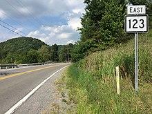
View east along WV 123 at US 52 in Brush Fork

West Virginia Route 123 is an east–west state highway located in the Bluefield, West Virginia area. The western terminus of the route is at the Virginia state line northwest of Bluefield, where WV 123 continues west as secondary State Route 643. The eastern terminus is at U.S. Route 19 and U.S. Route 460 northeast of Bluefield.

Major intersections

The entire route is in Mercer County.

LocationmikmDestinationsNotes
SR 643Virginia state line; to SR 102
Brush Fork US 52 – Welch, Bluefield
Green Valley US 19 / US 460 / CR 34 (Clover Dew Dairy Road) – Princeton, Bluefield
1.000 mi = 1.609 km; 1.000 km = 0.621 mi

References

  1. ^ Distance calculated using Microsoft MapPoint mapping software.


This article is copied from an article on Wikipedia® - the free encyclopedia created and edited by its online user community. The text was not checked or edited by anyone on our staff. Although the vast majority of Wikipedia® encyclopedia articles provide accurate and timely information, please do not assume the accuracy of any particular article. This article is distributed under the terms of GNU Free Documentation License.

Copyright © 2003-2025 Farlex, Inc Disclaimer
All content on this website, including dictionary, thesaurus, literature, geography, and other reference data is for informational purposes only. This information should not be considered complete, up to date, and is not intended to be used in place of a visit, consultation, or advice of a legal, medical, or any other professional.