Wikipedia

West Cape

West Cape (Te Waituna)
Te Waituna
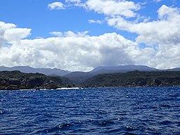
West Cape & Newton River Fiordland New Zealand Aotearoa.jpg
West Cape & Newton River Mouth, Fiordland, New Zealand
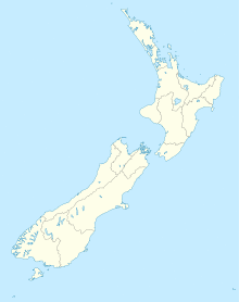
Map showing the location of West Cape (Te Waituna)
Location of West Cape within New Zealand
Coordinates45°54′22″S 166°25′39″E / 45.9060°S 166.4276°E

West Cape is the westernmost point in the main chain of islands of New Zealand. It is located in the far southwest of the South Island, within Fiordland National Park, between Tamatea / Dusky Sound and Taiari / Chalky Inlet.[1] The cape consists of a small rocky shore and low forest-covered sloping land, and is located just north of the Newton River mouth.

West Cape is one of the 4 New Zealand Cardinal Capes, as named by Captain James Cook, on his first voyage to the region in 1769-70.[2] The other Cardinal Capes named at the time are North Cape, Cape East, and Cape South.


References

  1. ^ "Place name detail: West Cape". New Zealand Gazetteer. New Zealand Geographic Board. Retrieved 25 March 2010.
  2. ^ Chart Of New Zealand - J Cook 1769-70 [1]. Retrieved on 7 Dec 2017.

This article is copied from an article on Wikipedia® - the free encyclopedia created and edited by its online user community. The text was not checked or edited by anyone on our staff. Although the vast majority of Wikipedia® encyclopedia articles provide accurate and timely information, please do not assume the accuracy of any particular article. This article is distributed under the terms of GNU Free Documentation License.

Copyright © 2003-2025 Farlex, Inc Disclaimer
All content on this website, including dictionary, thesaurus, literature, geography, and other reference data is for informational purposes only. This information should not be considered complete, up to date, and is not intended to be used in place of a visit, consultation, or advice of a legal, medical, or any other professional.