)
The schloss
Vollrathsruhe | |
|---|---|
Location of Vollrathsruhe within Mecklenburgische Seenplatte district ) | |
) Vollrathsruhe ) Vollrathsruhe | |
| Coordinates: 53°38′35″N 12°29′24″E / 53.64306°N 12.49000°E | |
| Country | Germany |
| State | Mecklenburg-Vorpommern |
| District | Mecklenburgische Seenplatte |
| Municipal assoc. | Seenlandschaft Waren |
| Government | |
| • Mayor | Siegfried Grohmann |
| Area | |
| • Total | 31.24 km2 (12.06 sq mi) |
| Elevation | 70 m (230 ft) |
| Population (2019-12-31)[1] | |
| • Total | 392 |
| • Density | 13/km2 (32/sq mi) |
| Time zone | UTC+01:00 (CET) |
| • Summer (DST) | UTC+02:00 (CEST) |
| Postal codes | 17194 |
| Dialling codes | 039933 |
| Vehicle registration | MÜR |
| Website | www.amt-seenlandschaft-waren.de/index1.html |
Vollrathsruhe is a municipality in the Mecklenburgische Seenplatte district, in Mecklenburg-Vorpommern, Germany.
Sights
- Village Church, Kirch Grubenhagen.
- Vollrathsruhe Estate with two-storey, 13-wing country house, park and mausoleum
- Dat lange Hus in Hallalit is of architectural interest: at 104 metres long, it is the longest fieldstone house in the region. This cottage was built in the mid-19th century for 16 families.
- Ruins of the 13th-century Grubenhagen Castle in Vollrathsruhe
- Protected central avant-corps of a building in Kirch Grubenhagen, Teterower Str. 3
- Schloss Grubenhagen country house and park
- Hellgrund Nature Reserve, Klein Rehberg and
- Wüste und Glase Nature Reserve in Klein Luckow with a Bronze Age/Slavic burgwall.
Gallery
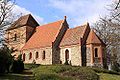
Church in Kirch Grubenhagen
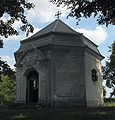
Chapel in the schloss park of Vollrathsruhe
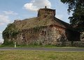
Fieldstone building in Vollrathsruhe
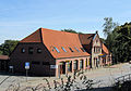
Building in Kirch Grubenhagen, Teterower Str. 3
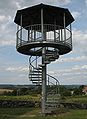
Viewing tower

The schloss, 2014 aerial photograph
)
)
)
)
)
)
References
- ^ "Statistisches Amt M-V – Bevölkerungsstand der Kreise, Ämter und Gemeinden 2019". Statistisches Amt Mecklenburg-Vorpommern (in German). July 2020.