Villefranche-de-Lauragais | |
|---|---|
) The church in Villefranche-de-Lauragais | |
.svg.gif')) Coat of arms | |
Location of Villefranche-de-Lauragais 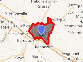 | |
) Villefranche-de-Lauragais ) Villefranche-de-Lauragais | |
| Coordinates: 43°24′02″N 1°43′08″E / 43.4006°N 1.7189°E | |
| Country | France |
| Region | Occitanie |
| Department | Haute-Garonne |
| Arrondissement | Toulouse |
| Canton | Revel |
| Government | |
| • Mayor (2008–2014) | Marie-Claude Bonnafous |
| Area 1 | 10.35 km2 (4.00 sq mi) |
| Population (Jan. 2017)[1] | 4,519 |
| • Density | 440/km2 (1,100/sq mi) |
| Time zone | UTC+01:00 (CET) |
| • Summer (DST) | UTC+02:00 (CEST) |
| INSEE/Postal code | 31582 /31290 |
| Elevation | 168–256 m (551–840 ft) (avg. 175 m or 574 ft) |
| 1 French Land Register data, which excludes lakes, ponds, glaciers > 1 km2 (0.386 sq mi or 247 acres) and river estuaries. | |
Villefranche-de-Lauragais is a commune in the Haute-Garonne department in southwestern France.
Population
| Year | Pop. | ±% |
|---|---|---|
| 1962 | 2,522 | — |
| 1968 | 2,771 | +9.9% |
| 1975 | 2,948 | +6.4% |
| 1982 | 3,127 | +6.1% |
| 1990 | 3,316 | +6.0% |
| 1999 | 3,348 | +1.0% |
| 2008 | 4,012 | +19.8% |
See also
References
- ^ "Populations légales 2017". INSEE. Retrieved 6 January 2020.