Vieux-Bourg | |
|---|---|
) The church in Vieux-Bourg | |
) Coat of arms | |
Location of Vieux-Bourg 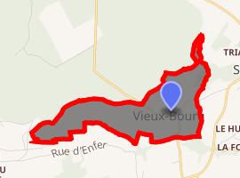 | |
) Vieux-Bourg ) Vieux-Bourg | |
| Coordinates: 49°18′43″N 0°15′01″E / 49.3119°N 0.2503°E | |
| Country | France |
| Region | Normandy |
| Department | Calvados |
| Arrondissement | Lisieux |
| Canton | Pont-l'Évêque |
| Government | |
| • Mayor (2008–2014) | Gérard Poulain |
| Area 1 | 1.30 km2 (0.50 sq mi) |
| Population (Jan. 2017)[1] | 78 |
| • Density | 60/km2 (160/sq mi) |
| Time zone | UTC+01:00 (CET) |
| • Summer (DST) | UTC+02:00 (CEST) |
| INSEE/Postal code | 14748 /14130 |
| Elevation | 44–135 m (144–443 ft) (avg. 65 m or 213 ft) |
| 1 French Land Register data, which excludes lakes, ponds, glaciers > 1 km2 (0.386 sq mi or 247 acres) and river estuaries. | |
Vieux-Bourg is a commune in the Calvados department in the Normandy region in northwestern France.
Population
| Year | Pop. | ±% |
|---|---|---|
| 1962 | 69 | — |
| 1968 | 74 | +7.2% |
| 1975 | 76 | +2.7% |
| 1982 | 90 | +18.4% |
| 1990 | 87 | −3.3% |
| 1999 | 74 | −14.9% |
| 2009 | 83 | +12.2% |
See also
References
- ^ "Populations légales 2017". INSEE. Retrieved 6 January 2020.