)
Transport in Guinea is composed by a variety of systems that people in the country use to get around as well as to and from domestic and international destinations.
The railway from Conakry to Kankan ceased operating in the mid-1980s.[1]
Domestic air services are intermittent. Most vehicles in Guinea are 20+ years old, and cabs are any four-door vehicle which the owner has designated as being for hire.
Locals, nearly entirely without vehicles of their own, rely upon these taxis (which charge per seat) and small buses to take them around town and across the country. There is some river traffic on the Niger and Milo rivers. Horses and donkeys pull carts, primarily to transport construction materials.
Iron mining at Simandou (South) in the southeast beginning in 2007 and at Kalia in the east is likely to result in the construction of a new heavy-duty standard gauge railway and deepwater port. Iron mining at Simandou (North) will load to a new port near Buchanan, Liberia, in exchange for which rehabilitation of the Conakry to Kankan line will occur.
Conakry International Airport is the largest airport in the country, with flights to other cities in Africa as well as to Europe.
Railways
total: 1,086 km
standard gauge: 279 km 1,435 mm (4 ft 8 1&fras1;2 in) gauge
metre gauge: 807 km 1,000 mm (3 ft 3 3&fras1;8 in) gauge (includes 662 km in common carrier service from Kankan to Conakry)[2]
The lines do not all connect.
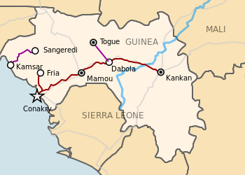
Cities served by rail
Proposed North Trans-Guinean Railway
This 135 km long Standard Gauge railway connects bauxite mines at Boffa with a new port at Boké, both places in the north of Guinea.
A Joint Venture has already launched the $US 3bn Boffa – Boké Project which a 135km line from the Dapilon River Terminal to new mining areas of Santou II and Houda. [3]
See: Boffa-Boke Railway
Northern line
This line is 1,435 mm (4 ft 8 1&fras1;2 in) gauge (standard gauge) and carries about 12,000,000 t (11,810,478 long tons; 13,227,736 short tons) per annum.
- Port Kamsar - port
- Boké
- Crossing with proposed B B line. Both 1435mm gauge. By bridge or by level crossing.
- Rail Sangarédi - bauxite mine
Central line
This line is 1,000 mm (3 ft 3 3&fras1;8 in) gauge and head off in a northwestern direction.
Southern line
This line is 1,000 mm (3 ft 3 3&fras1;8 in) gauge. Conversion to 1,435 mm (4 ft 8 1&fras1;2 in) gauge has been proposed.[4]
- Conakry - capital and port.
- Kindia - provincial capital.
- Kolèntèn
- Konkouré - several km north of railway
- Mamou - provincial capital
- Kégnégo
- Dabola - junction and break of gauge
- Bissikrima
- Cisséla -
- Kouroussa - bridge over Niger River
- Kankan - terminus and provincial capital.
This line is 1,435 mm (4 ft 8 1&fras1;2 in).
South Western line
This line is 1,435 mm (4 ft 8 1&fras1;2 in) and parallels the Southern line.
- Conakry - capital and port. Rail Map (red dots) Rail Map (gray lines)
- Kindia - bauxite mine.
Proposed South Trans-Guinean Railway
The heavy duty Transguinean Railways is about 650 km long and would be 1,435 mm (4 ft 8 1&fras1;2 in) (standard gauge). It goes from iron ore mines in the south east and bauxite mines in the north to a new port a Matakong.[6]
- Matakong - Deep water port
- Forécariah
- Madina Woula - way station
- Bambafouga - junction
- Marela - way station
- Faranah
- Tiro
- Kissidougou - way station
- Macenta
- Koule
- Nzerekore
- Lola
- Simandou iron ore deposit near Diéké
- Nimba - iron ore
- Pontiola - bauxite
- Tougué - branch terminus - bauxite
Timeline
2008
- July 2008 - wobbles over Simandou leases [7]
- four ex-Croatian locomotives refurbished and regauged in Russia [8]
1994
- Progress [9]
Statistics
Highways
total: 30,500 km
paved: 5,033 km
unpaved: 25,467 km (1996 est.)
The Trans–West African Coastal Highway crosses Guinea, connecting it to Bissau (Guinea-Bissau), and when construction in Sierra Leone and Liberia is complete, to a total of 13 other nations of the Economic Community of West African States (ECOWAS).
Waterways
1,295 km navigable by shallow-draft native craft
Ports and harbors
Merchant marine
none (1999 est.)
Airports
15 (1999 est.)
Airports - with paved runways
total: 5
over 3,047 m: 1
2,438 to 3,047 m: 1
1,524 to 2,437 m: 3 (1999 est.)
The airport code for the capital, Conakry, is CKY.
Airports - with unpaved runways
total: 10
1,524 to 2,437 m: 5
914 to 1,523 m: 4
under 914 m: 1 (1999 est.)
See also
References
- ^ "Railways in Guinea". sinfin.net. Retrieved 2016-08-10.
- ^ United States Central Intelligence Agency (1997). "The World Factbook". Retrieved January 16, 2020.
- ^ Santou mines - Dapilon port
- ^ Janes World Railways 2002-2003 p182
- ^ Janes World Railways 2002-2003 p102
- ^ "Transguinean". www.teamgroup.it. Retrieved 2018-12-15.
- ^ "Archived copy". Archived from the original on 2008-07-31. Retrieved 2018-12-28.
- ^ Railway Gazette International February 2008 p73
- ^ Izon, David (June 1995). "The Mineral Industry of Guinea" (PDF). minerals.usgs.gov. Retrieved 2018-12-15.