Stechlin | |
|---|---|
Location of Stechlin within Oberhavel district ) | |
) Stechlin ) Stechlin | |
| Coordinates: 53°06′N 13°02′E / 53.100°N 13.033°E | |
| Country | Germany |
| State | Brandenburg |
| District | Oberhavel |
| Municipal assoc. | Gransee und Gemeinden |
| Subdivisions | 3 districts |
| Government | |
| • Mayor | Wolfgang Kielblock (WG HVD) |
| Area | |
| • Total | 83.95 km2 (32.41 sq mi) |
| Elevation | 83 m (272 ft) |
| Population (2019-12-31)[1] | |
| • Total | 1,192 |
| • Density | 14/km2 (37/sq mi) |
| Time zone | UTC+01:00 (CET) |
| • Summer (DST) | UTC+02:00 (CEST) |
| Postal codes | 16775 |
| Dialling codes | 033082 |
| Vehicle registration | OHV |
| Website | www.stechlin.de |
Stechlin is a municipality in the Oberhavel district, in Brandenburg, Germany.
Geography
Stechlin is part of the northern border of Brandenburg, at the start of the Mecklenburg Lake District. It is part of the Stechlin-Ruppiner Land Nature Park, surrounded by the Menzer Forest and has many lakes in the area. The most famous is Lake Stechlin (Stechlinsee) which is a protected area.
Districts of Stechlin
- Dagow
- Dollgow
- Güldenhof
- Menz
- Neuglobsow
- Neuroofen
- Schulzenhof
Demography
)
Development of population since 1875 within the current boundaries (Blue line: Population; Dotted line: Comparison to population development of Brandenburg state; Grey background: Time of Nazi rule; Red background: Time of communist rule)
|
|
|
District Authority
Stechlin is in the borough of Gransee. Stechlin has its own council that is responsible for 3 districts:
- Dollgow with Schulzenhof and Güldenhof
- Neuglobsow with Dagow
- Menz with Neuroofen
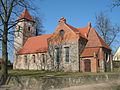
Church in Menz
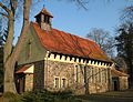
Church in Neuglobsow
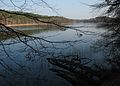
Lake Roofen in Menz
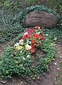
Erwin Strittmatter's grave in Schulzenhof
)
)
)
)
See also
- Roofensee
References
- ^ "Bevölkerung im Land Brandenburg nach amtsfreien Gemeinden, Ämtern und Gemeinden 31. Dezember 2019". Amt für Statistik Berlin-Brandenburg (in German). July 2020.
- ^ Detailed data sources are to be found in the Wikimedia Commons.Population Projection Brandenburg at Wikimedia Commons