| Sorell Council Tasmania | |||||||||||||||
|---|---|---|---|---|---|---|---|---|---|---|---|---|---|---|---|
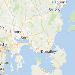 Map showing the Sorell local government area. | |||||||||||||||
| Coordinates | 42°46′51″S 147°41′25″E / 42.7808°S 147.6904°E | ||||||||||||||
| Population | 15,218 (2018)[1] | ||||||||||||||
| • Density | 26.058/km2 (67.49/sq mi) | ||||||||||||||
| Established | 1 January 1862 | ||||||||||||||
| Area | 584 km2 (225.5 sq mi)[1] | ||||||||||||||
| Mayor | Kerry Vincent | ||||||||||||||
| Council seat | Sorell | ||||||||||||||
| Region | Sorell and surrounds | ||||||||||||||
| State electorate(s) | Lyons | ||||||||||||||
| Federal Division(s) | Lyons | ||||||||||||||
| Website | Sorell Council | ||||||||||||||
| |||||||||||||||
)
Sorell Council is a local government body in Tasmania, situated in the south-east of the state. The Sorell local government area is classified as rural and has a population of 15,218,[1] the major centres of the region include Dodges Ferry, Dunalley, Primrose Sands and the principal town of Sorell.
History and attributes
The Sorell Municipal Council was established on 1 January 1862.[2] Sorell is classified as rural, agricultural and very large (RAV) under the Australian Classification of Local Governments.[3]
Marion Bay, on the council's east coast, is host to the Tasmanian Falls Festival, an annual event first held in Tasmania on New Year's Eve in December 2003.
Suburbs
| Suburb | Census population 2011 | Reason |
|---|---|---|
| Shark Point | Incl. in Penna | |
| Midway Point | 2598 | |
| Penna | 403 | |
| Sorell | 2476 | |
| Forcett | 635 | |
| Lewisham | 881 | |
| Dodges Ferry | 2319 | |
| Carlton | 1241 | |
| Primrose Sands | 934 | |
| Carlton River | Incl. in Connellys Marsh | |
| Connellys Marsh | 179 | Includes Carlton River |
| Dunalley | 274 | |
| Boomer Bay | 199 | Includes Marion Bay |
| Marion Bay | Incl. in Boomer Bay | |
| Bream Creek | Incl. in Kellevie | |
| Nugent | Incl. in Wattle Hill | |
| Wattle Hill | 334 | Includes Nugent, Pawleena |
| Pawleena | Incl. in Wattle Hill | |
| Orielton | 345 | |
| Copping | Incl. in Kellevie | |
| Kellevie | 417 | Includes Copping, Bream Creek |
| Total | 13325 | |
| (41) | Variance | |
| Local government total | 13,194 | Gazetted Sorell Council Local Government Area |
See also
- List of local government areas of Tasmania
References
- ^ a b c "3218.0 – Regional Population Growth, Australia, 2017-18: Population Estimates by Local Government Area (ASGS 2018), 2017 to 2018". Australian Bureau of Statistics. Australian Bureau of Statistics. 27 March 2019. Retrieved 25 October 2019. Estimated resident population, 30 June 2018.
- ^ "Agency Details: Sorell Municipal Council". search.archives.tas.gov.au. Tasmanian Government. Retrieved 11 June 2018.
- ^ "Local government national report 2014-2015". regional.gov.au. Australian Government. Retrieved 8 June 2018.
- ^ Australian Bureau of Statistics. "2011 Census QuickStats". Retrieved 29 May 2016.