Sham Shui Po 深水埗區 | |
|---|---|
| Sham Shui Po District | |
) Day view of the Sham Shui Po District skyline | |
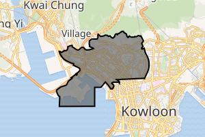 | |
) Location of Sham Shui Po within Hong Kong | |
| Coordinates: 22°19′51″N 114°09′44″E / 22.33074°N 114.16220°E | |
| Country | |
| Region | Kowloon |
| Constituencies | 21 |
| Government | |
| • District Council chairman | Yeung Yuk (ADPL) |
| • District Council Vice-chairwoman | Ng Yuet Lan,Janet |
| • District Officer | Damian Kwok-hung Lee |
| Area | |
| • Total | 9.48 km2 (3.66 sq mi) |
| Population (2016[1]) | |
| • Total | 405,869 |
| • Density | 43,000/km2 (110,000/sq mi) |
| Time zone | UTC+8 (Hong Kong Time) |
| Largest neighbourhood by population | Sham Shui Po (60,161 – 2016 est)[2] |
| Website | Sham Shui Po District Council |
| Sham Shui Po District | |||||||||||||||
|---|---|---|---|---|---|---|---|---|---|---|---|---|---|---|---|
| Traditional Chinese | 深水埗區 | ||||||||||||||
| Simplified Chinese | 深水埗区 | ||||||||||||||
| Jyutping | Sam1seoi2bou2 keoi1 | ||||||||||||||
| |||||||||||||||
Sham Shui Po District is one of 18 districts of Hong Kong. It is the poorest district in Hong Kong, with a predominantly working-class population of 405,869 in 2016 and the lowest median household income of all districts.[3] Sham Shui Po has long been home to poorer new immigrants from mainland China. It also saw the birth of public housing in Hong Kong, as the government sought to resettle those displaced by a devastating fire in its slums. Sham Shui Po also hosted a Vietnamese refugee camp during the influx of migration in the aftermath of the Vietnam War.
The district covers the Shek Kip Mei, Sham Shui Po, Cheung Sha Wan, Lai Chi Kok and Yau Yat Chuen areas of New Kowloon, and Stonecutters Island of Kowloon.
Administration
Sham Shui Po District administers:
- Cheung Sha Wan 長沙灣 – Between Tonkin Street and Kom Tsun Street/Butterfly Valley Road.
- MTR stations: Cheung Sha Wan station, Lai Chi Kok station
- Western Part of Kowloon Tong 九龍塘 – West of the route of East Rail line, north of Boundary Street and east of Tai Hang Tung Road, where Yau Yat Tsuen 又一村 and Tai Hang Tung Estate are situated.
- MTR station: Kowloon Tong station (East Rail)
- Lai Chi Kok 荔枝角 – West of Kom Tsun Street/Butterfly Valley Road to east of Lai King, Kwai Chung.
- MTR station: Mei Foo station
- Sham Shui Po 深水埗 – Between Tonkin Street and Boundary Street
- MTR stations: Sham Shui Po station, Nam Cheong station
- Shek Kip Mei 石硤尾 – East of Tai Po Road, North of Boundary Street, west of Tai Hang Tung Road, where Eastern part of Kowloon Tsai (Nam Shan Estate) is situated.
- MTR station: Shek Kip Mei station
- So Uk 蘇屋 – Between Po on Road and Ching Cheung Road/Tai Po Road.
- Stonecutters Island 昂船洲 – Excluding the reclaimed lands for Container Terminal 8 which is located in north of Hing Wah Street West and Ngong Shuen Chau Viaduct.
Demographics and housing
)
.jpg'))
)
Sham Shui Po was already a densely populated district in the 1950s and 1960s. It is poverty-stricken, having the lowest median monthly domestic household income among the 18 districts. It has the highest percentage of elderly people over 65 years. The percentage of new immigrants is also very high. Living conditions of grass-roots families in this district remain a social issue.[4]
Mei Foo Sun Chuen in Lai Chi Kok, built in 1968 - 1978, was Hong Kong's first large-scale private housing estate. It comprises eight phases with a total of 99 blocks.[5]
Public Housing
There are 18 public housing estates in the Sham Shui Po District, divided into sub-districts:
- Cheung Sha Wan
- Cheung Sha Wan Estate
- Fortune Estate
- Hoi Lai Estate
- Hoi Ying Estate
- Lai Tsui Court
- Lei Cheng Uk Estate
- So Uk Estate
- Un Chau Estate
- Sham Shui Po
- Cronin Garden
- Fu Cheong Estate
- Lai Kok Estate
- Lai On Estate
- Nam Cheong Estate
- Wing Cheong Estate
- Shek Kip Mei
- Chak On Estate
- Nam Shan Estate
- Pak Tin Estate
- Shek Kip Mei Estate
- Tai Hang Tung Estate
- Tai Hang Sai Estate
University
The main campus of City University of Hong Kong, was located in Tat Chee Avenue,[6] Sham Shui Po District.[7]
Transport
There are four railway lines serving Sham Shui Po District:
MTR
)
- Kwun Tong line: Shek Kip Mei
- Tsuen Wan line: Sham Shui Po, Cheung Sha Wan, Lai Chi Kok, Mei Foo.
- Tung Chung line: Nam Cheong.
- West Rail line: Mei Foo, Nam Cheong.
Buses
There are also various bus routes serving the district. Most of them are operated by Kowloon Motor Bus, and some by New World First Bus and Citybus. These three companies also jointly operate some routes, most of these crossing the harbour to the Hong Kong Island.
- Kowloon Motor Bus: 2, 2A, 2B, 2D, 2E, 2F, 6, 6A, 6C, 6D, 6F, 12, 12A, 13P, 18, 30, 30X, 31B, 32, 33A, 35A, 36A, 36B, 37, 38, 38A, 40, 40P, 41, 42, 42A, 42C, 43C, 44, 45, 46, 46X, 52X, 58X, 59X, 60X, 61X, 62X, 63X, 66X, 67X, 68X, 69X, 72, 81, 86, 86A, 86C, 87B, 98C, 98S, 203C, 212, 230X, 234X, 238X, 242X, 258D, 259C, 259D, 265B, 268C, 269C, 286C, 296C
- New World First Bus: 701, 701S, 702, 702A, 702S, 796C, 970, 970X, 971
- Citybus: A21, E21, E21A, E22, E22A, E22P, E22S, E22X, N21, N21A, N26, N29
- Cross Harbour Tunnel: 102, 102P, 102R, 104, 112, 117, 118, 118P, 171, 171A, 171P, 904, 905, 914, 914P, 914X, N118, N122, N171
See also
- Politics of Hong Kong
- Sham Shui Po SA
References
- ^ "2016 Population Census: Summary Results Table A201a Population by District Council District and Year" (in English and Chinese). Census and Statistics Department, Hong Kong Government. 2016. Retrieved 24 May 2018.
- ^ District Profiles, Hong Kong Government, 8 December 2017, retrieved 15 April 2020
- ^ Basic Tables for District Council Districts: Hong Kong 2006 By-Census
- ^ "Living conditions in city's poorest district getting worse". South China Morning Post. 23 April 2017. Retrieved 5 June 2020.
- ^ "The birth of Hong Kong's middle class: Mei Foo Sun Chuen, the first private housing estate". South China Morning Post. Retrieved 5 June 2020.
- ^ "City University of Hong Kong". City University of Hong Kong. Retrieved 5 June 2020.
- ^ "District Council Constituency Boundaries - Sham Shui Po District" (PDF). Hong Kong: Electoral Affairs Commission. January 2015. Retrieved 5 April 2019.