| Line 3 | |
|---|---|
 | |
| Overview | |
| Native name | 3호선(三號線) Sam Hoseon |
| Status | Operational |
| Termini | Daehwa Ogeum |
| Stations | 44 34-Seoul Metro 10-Korail |
| Service | |
| Type | Rapid transit |
| System | Seoul Metropolitan Subway |
| Operator(s) | Seoul Metro & Korail |
| History | |
| Opened | July 12, 1985 |
| Technical | |
| Line length | 57.4 km (35.7 mi) 38.2 km (23.7 mi) Seoul Metro[1] 19.2 km (11.9 mi) Korail[2] |
| Number of tracks | 2 |
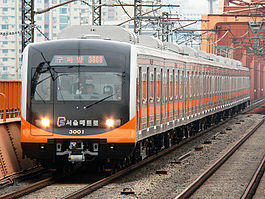
Seoul Subway Line 3 (dubbed The Orange Line) of the Seoul Metropolitan Subway is a rapid transit and commuter rail service that connects Goyang, northwestern Seoul to the city center, Gangnam and southeastern Seoul.
In December 2010 the line is recorded as having the second highest WiFi data consumption in the Seoul Metropolitan area. It averaged 1.8 times more than the other 14 subway lines fitted with WiFi service zones.[3]
History
Construction began in 1980, and most of the current line opened (Gupabal–Yangjae; Jichuk opened in 1990) after completion of work in two stages during 1985, along with brother subway Line 4. In October 1993, a second extension to the south was opened (Yangjae–Suseo), giving Seoul the current Line 3.
In March 1996, the Ilsan Line (Daehwa–Jichuk), which is considered the third extension to the north was opened, and connected the city of Goyang with Seoul. Seoul's portion of Line 3 and the Ilsan part of Line 3 operate as one combined line, with trains running from one end to the other. The respective stations are operated by two different companies, though, so they are sometimes listed separately. There are 2 depots near Jichuk station and Suseo station, which are for both Korail and Seoul Metro.
A 3 km extension opened on February 18, 2010, stretching from Suseo to Garak Market (Line 8) and Ogeum (Line 5).
On December 27, 2014, Wonheung station opened between Wondang and Samsong stations.
Tourism
In January 2013, the Seoul Metropolitan Rapid Transit Corporation, published free guidebooks in three languages: English, Japanese and Chinese (simplified and traditional), which features eight tours as well as recommendations for accommodations, restaurants and shopping centers. The tours are designed with different themes for travel along the subway lines, e.g. Korean traditional culture. Which goes from Jongno 3-ga station to Anguk station and Gyeongbokgung station on this line that showcases antique shops and art galleries of Insa-dong.[4]
Stations
| Station Number | Station Name English | Station Name Hangul | Station Name Hanja | Transfer | Line Name | Distance in km | Total Distance | Location | |
|---|---|---|---|---|---|---|---|---|---|
| Daehwa | 대화 | 大化 | |||||||
| Juyeop | 주엽 | 注葉 | |||||||
| Jeongbalsan (Goyang Aramnuri Art Center) | 정발산 | 鼎鉢山 | |||||||
| Madu | 마두 | 馬頭 | |||||||
| Baekseok (National Health Insurance Ilsan Hospital) | 백석 | 白石 | |||||||
| Daegok | 대곡 | 大谷 | |||||||
| Hwajeong | 화정 | 花井 | |||||||
| Wondang | 원당 | 元堂 | |||||||
| Wonheung | 원흥 | 元興 | |||||||
| Samsong | 삼송 | 三松 | |||||||
| Jichuk | 지축 | 紙杻 | |||||||
| Gupabal | 구파발 | 舊把撥 | |||||||
| Yeonsinnae | 연신내 | 연신내 | |||||||
| Bulgwang | 불광 | 佛光 | |||||||
| Nokbeon | 녹번 | 碌磻 | |||||||
| Hongje (Seoul Culture Arts Univ.) | 홍제 | 弘濟 | |||||||
| Muakjae | 무악재 | 毋岳재 | |||||||
| Dongnimmun | 독립문 | 獨立門 | |||||||
| Gyeongbokgung (Government Complex-Seoul) | 경복궁 | 景福宮 | |||||||
| Anguk | 안국 | 安國 | |||||||
| Jongno 3(sam)-ga | 종로3가 | 鍾路3街 | |||||||
| Euljiro 3(sam)-ga | 을지로3가 | 乙支路3街 | |||||||
| Chungmuro | 충무로 | 忠武路 | |||||||
| Dongguk University (The Shilla Duty Free) | 동대입구 | 東大入口 | |||||||
| Yaksu | 약수 | 藥水 | |||||||
| Geumho | 금호 | 金湖 | |||||||
| Oksu | 옥수 | 玉水 | |||||||
| Apgujeong (Hyundai Department Store) | 압구정 | 狎鷗亭 | |||||||
| Sinsa | 신사 | 新沙 | |||||||
| Jamwon | 잠원 | 蠶院 | |||||||
| Express Bus Terminal | 고속터미널 | 高速터미널 | |||||||
| Seoul Nat'l Univ. of Education (Court & Public Prosecutor's Office) | 교대 | 敎大 | |||||||
| Nambu Bus Terminal (Seoul Arts Center) | 남부터미널 | 南部터미널 | |||||||
| Yangjae (Seocho-gu Office) | 양재 | 良才 | |||||||
| Maebong | 매봉 | 매봉 | |||||||
| Dogok | 도곡 | 道谷 | |||||||
| Daechi | 대치 | 大峙 | |||||||
| Hangnyeoul | 학여울 | 학여울 | |||||||
| Daecheong | 대청 | 大淸 | |||||||
| Irwon | 일원 | 逸院 | |||||||
| Suseo | 수서 | 水西 | |||||||
| Garak Market | 가락시장 | 可樂市場 | |||||||
| National Police Hospital | 경찰병원 | 警察病院 | |||||||
| Ogeum | 오금 | 梧琴 | |||||||
See also
References
- ^ 지하철건설현황 [Status of Subway Construction] (in Korean). Seoul City Government. Retrieved February 22, 2014.
- ^ "Metro Lines & Trains in Operation". Korail. Retrieved July 25, 2014.
- ^ "Seoul Subway Line No. 2 Becomes Major WiFi Hotspot". Chosun Ilbo. December 24, 2010. Retrieved April 25, 2012.
- ^ Kwon, Sang-soo (January 26, 2013). "Free guide for Seoul's subway riders". Joongang Daily. Archived from the original on April 12, 2013. Retrieved January 27, 2013.
External links
- Seoul Metropolitan Government's Line 3 extension page (in Korean) includes a route map and status information for the extension from Suseo to Garak Market.
- UrbanRail.Net's Seoul Subway Page
- Map, station and route finder