Schwarzwald-Baar-Kreis | |
|---|---|
District | |
 | |
| Country | Germany |
| State | Baden-Württemberg |
| Adm. region | Freiburg |
| Capital | Villingen-Schwenningen |
| Area | |
| • Total | 1,025.23 km2 (395.84 sq mi) |
| Population (31 December 2019)[1] | |
| • Total | 212,506 |
| • Density | 210/km2 (540/sq mi) |
| Time zone | UTC+01:00 (CET) |
| • Summer (DST) | UTC+02:00 (CEST) |
| Vehicle registration | VS |
| Website | http://www.schwarzwald-baar-kreis.de |
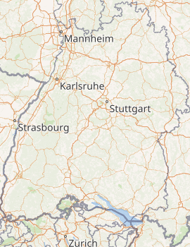
Schwarzwald-Baar is a Landkreis (district) in the south of Baden-Württemberg, Germany. Neighboring districts are (from north clockwise) Ortenaukreis, Rottweil, Tuttlingen, Constance, the Swiss canton of Schaffhausen, and the districts Waldshut, Breisgau-Hochschwarzwald and Emmendingen.
History
The district was created in 1973, when the two districts Donaueschingen and Villingen were merged.
Geography
The district got its name from the two predominant landscapes in the district. The Black Forest (Schwarzwald), and the Baar, the foothills between the Black Forest and the Swabian Alb. Both the Danube River and the Neckar River have their origins in the Schwarzwald and Baar district.
Coat of arms
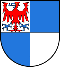 | The coat of arms is modeled after the two coat of arms of the cities of Villingen and Schwenningen. Villingen had a horizontally divided blue-and-white arms, while Schwenningen had a vertically divided blue-and-white arms. Combining both divisions gives the four fields. The eagle in the top-left quarter is taken from the coat of arms of the city of Villingen, and derives from the Zähringen family who ruled that city in the 13th century. |
Cities and towns
)
Towns and municipalities in Schwarzwald-Baar-Kreis
| Cities | Administrative districts | Towns |
|---|---|---|
|
|
References
- ^ "Bevölkerung nach Nationalität und Geschlecht am 31. Dezember 2019". Statistisches Landesamt Baden-Württemberg (in German). September 2020.
External links
- Official website (German)