| Saint Vincent Passage | |
|---|---|
| Coordinates | 13°30′N 61°00′W / 13.500°N 61.000°W |
| Basin countries | Saint Lucia Saint Vincent and the Grenadines |
| Max. length | 4.5 miles (7.2 km) ~ 10 miles (16 km) |
| Max. width | 23 miles (37 km) |
Saint Vincent Passage is a strait in the Caribbean, that separates the Saint Lucia and Saint Vincent. It is a pathway between Caribbean sea and Atlantic ocean.[1] [2]

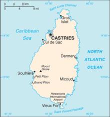
Saint Lucia with the Saint Vincent Passage at the bottom.
| [Interactive fullscreen map] |
| Location between Saint Lucia and Saint Vincent |
See also
References
- ^ Ana G. López Martín International Straits: Concept, Classification and Rules of Passage. 218 pages. Publisher: Springer Science & Business Media, 2010 ISBN 9783642129063
- ^ Jorge Heine, Leslie F. Manigat The Caribbean and World Politics: Cross Currents and Cleavages Pages 385 Publisher: Holmes & Meier, 1988 ISBN 978-0841910003 page 31
