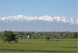
| Spīn Ghar | |
|---|---|
| Pashto: سپین غر Persian: سفیدکوه (Safēd Kōh); English: Safed Koh | |
 Speen Ghar starting from Eastern Afghanistan to deep Khyber Pakhtunkhwa, Pakistan. | |
| Highest point | |
| Peak | Mount Sikaram, Afghanistan–Pakistan Border |
| Elevation | 4,761 m (15,620 ft) |
| Geography | |
| Countries | Afghanistan and Pakistan |
| Provinces | Nangargar, Afghanistan and Khyber Pakhtunkhwa, Pakistan |
.jpg)
Spīn Ghar (Pashto: سپین غر) or Safēd Kōh[1][2][3][4][5] (Persian: سفیدکوه, meaning "white mountain" in Persian) is a mountain range in eastern Afghanistan, which expands into Khyber Pakhtunkhwa, Pakistan. Its highest peak is Mount Sikaram on the Afghanistan–Pakistan border, which towers above all surrounding hills to 4,761 m (15,620 ft) above mean sea level.[6]
The Kabul River cuts a narrow trough through the Safēd Kōh mountains to flow eastward into the Indus River; otherwise, the range connects directly with the Shandur Top offshoot of the Hindu Kush mountain system.[1] The closest cities to the Safēd Kōh are Jalalabad, Afghanistan to the north; Gardez, Paktia Province, Afghanistan to the west; and Khost, Khost Province, Afghanistan and Parachinar, Kurram District, Khyber Pakhtunkhwa province, Pakistan to the south. From the highest peak of the mountain range, (Mount Sikaram (Sikaram Sar)), eastward, it passes on the north of Parachamkani, Afghanistan; Tari Mangal, Pewar, Alizai, Khewas, Shilawzan, Luqman Khel, Maikay, Chappri Rest House, Zeran, and Upper Khyber Agency.
There are a few notable mountain passes in or near the Safēd Kōh mountain range. The famous Khyber Pass crosses a spur of the Safēd Kōh. A second crossing, near Mount Sikaram, is called Piewar-Kotal or Gawi Pass and connects Parachinar city in the Federally Administered Tribal Areas with the Aryob Valley of Paktia Province, Afghanistan.
It is situated in the East of 'Dra Khebar'.
Above the nearly barren lower slopes, forests of pine and deodar cedar thrived on the main range, but devastation during the Afghan civil war reduced timber resources. The valleys still support some agriculture.
According to US military intelligence, many al-Qaeda fighters, including Osama Bin Laden, crossed the Safēd Kōh to escape to Pakistan during the Tora Bora offensive in 2001. After 2004, the Safēd Kōh mountain range was a pivotal place and theater of many battles fought between the foreign fighters of al-Qaeda and the joint Northern Command of the Pakistani military, with the latter trying to prevent the foreign fighters' incursion into Pakistan.
See also
- List of mountain ranges of the world
- List of highest mountains (a list of mountains above 7,200m)
References
- ^ a b Safīd Mountain Range in Encyclopædia Britannica, 2009
- ^ Chisholm, Hugh, ed. (1911). . Encyclopædia Britannica. 23 (11th ed.). Cambridge University Press. pp. 994–995.
- ^ Oxford dictionary
- ^ CIA
- ^ Garren, William R., and Carl R. Page. 1987. Gazetteer of Pakistan: official standard names approved by the United States Board on Geographic Names. Washington, D.C.: Congressional Information Service. p.578
- ^ defense.gov