Wikipedia

Rondeslottet

Rondslottet
RondslottetFromVeslesmeden.jpg
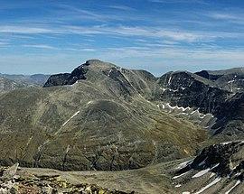
Rondslottet seen from Veslesmeden
Highest point
Elevation2,178 m (7,146 ft)
Prominence1,232 m (4,042 ft) [1]
Isolation53.5 to 53.7 km (33.2 to 33.4 mi) Edit this on Wikidata
Listing3 at List of highest points of Norwegian counties
Coordinates61°54′59″N 9°51′10″E / 61.91639°N 9.85278°E
Geography
LocationDovre and Folldal, Innlandet and Vestland, Norway
Parent rangeRondane
Topo map1718 I Rondane

Rondslottet is the highest mountain in the Rondane mountain range in the county of Innlandet.

The name

For the first element, see Rondane. The last element is the finite form of slott 'palace'.

See also

References

  1. ^ The key col is at the watershed between Dombås and Hjerkinn, more specifically south of Hjorttjønnin at Fokstugumyrin, 946 m (3,104 ft) above sea level.

Guidebooks

  • A. Dyer et al. "Walks and Scrambles in Norway", ISBN 1-904466-25-7.
  • Bernhard Pollmann "Norway South", ISBN 3-7633-4807-7.
This article is copied from an article on Wikipedia® - the free encyclopedia created and edited by its online user community. The text was not checked or edited by anyone on our staff. Although the vast majority of Wikipedia® encyclopedia articles provide accurate and timely information, please do not assume the accuracy of any particular article. This article is distributed under the terms of GNU Free Documentation License.

Copyright © 2003-2025 Farlex, Inc Disclaimer
All content on this website, including dictionary, thesaurus, literature, geography, and other reference data is for informational purposes only. This information should not be considered complete, up to date, and is not intended to be used in place of a visit, consultation, or advice of a legal, medical, or any other professional.