Reddersburg | |
|---|---|
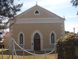
 Old Reformed church in Boshoff Street, Reddersburg | |
| Coordinates: 29°39′S 26°10′E / 29.650°S 26.167°E | |
| Country | South Africa |
| Province | Free State |
| District | Xhariep |
| Municipality | Kopanong |
| Established | 1861[1] |
| Government | |
| • Type | Municipality |
| • Mayor | Xolile Mathwa[2] (ANC) |
| Area | |
| • Total | 20.1 km2 (7.8 sq mi) |
| Population (2011)[3] | |
| • Total | 4,886 |
| • Density | 240/km2 (630/sq mi) |
| Racial makeup (2011) | |
| • Black African | 85.7% |
| • Coloured | 2.8% |
| • Indian/Asian | 0.3% |
| • White | 10.9% |
| • Other | 0.3% |
| First languages (2011) | |
| • Sotho | 65.7% |
| • Xhosa | 15.7% |
| • Afrikaans | 14.0% |
| • Sign language | 1.7% |
| • Other | 2.8% |
| Time zone | UTC+2 (SAST) |
| Postal code (street) | 9904 |
| PO box | 9904 |
| Area code | 051 |
Reddersburg is a small sheep and cattle farming town in the Free State province of South Africa on the N6 National Route 60 kilometres south of Bloemfontein.
History
The town was established around the Reformed Church Reddersburg, which was established on the farm Thorbeck on 7 May 1859. The church counsel bought the farm Vlakfontein to establish the town. The name is Afrikaans and means "Saviour's Town", from "God is our Saviour". The town was managed by the church until 1894 when it was handed over to the municipality on agreement that a hereditary tenure of 33 pounds sterling must be paid by the municipality to the church on an annual basis.
During the Second Boer War, Reddersburg was the site of one of the last victories for the Boer forces over the British. Troops led by General Christiaan de Wet attacked a convoy of 600 of the Royal Irish Rifles on April 4, 1900, and obtained their surrender the next day.[4]
The Sarie Marais Hotel is one of the landmarks in the town.
References
- ^ "Chronological order of town establishment in South Africa based on Floyd (1960:20-26)" (PDF). pp. xlv–lii.
- ^ Free State Tourism.org
- ^ a b c d Sum of the Main Places Matoporong and Reddersburg from Census 2011.
- ^ Thomas Pankenham, The Boer War (Random House, 1979) p417

