| Provinces and Indigenous regions of Panama Provincias y regiones indígenas de Panamá (Spanish) | |
|---|---|
| Category | Unitary state |
| Location | Republic of Panama |
| Number | 10 provinces 3 indigenous regions |
| Populations | (Provinces):48,378 (Darién) – 1,410,175 (Panamá) (Indigenous Regions): 10,001 (Emberá) – 156,747 (Ngäbe-Buglé) |
| Areas | (Provinces):2,362.0 km2 (912.0 sq mi) (Herrera) – 11,892.5 km2 (4,591.7 sq mi) (Darién) (Indigenous Regions) 4,393.9 km2 (1,696.5 sq mi) (Emberá) - 6,814.2 km2 (2,631.0 sq mi) (Ngäbe-Buglé) |
| Government | Provincial Government, National Government |
| Subdivisions | District |
)
Panama is divided into ten provinces (Spanish: provincias). There are four provincial-level indigenous regions (Spanish: comarcas indígenas, often foreshortened to comarcas).
There are also two indigenous comarcas within provinces that are considered equivalent to a corregimiento (municipality).
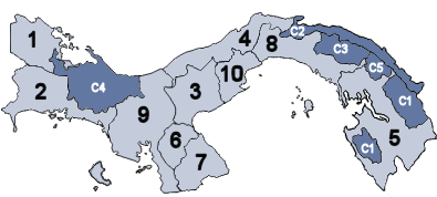
A map of Panama showing its ten provinces (light blue) and three provincial-level comarcas indígenas (indigenous regions) (dark blue).
Provinces
| Province | Capital | Area (km2)[1] | Population (2010 census)[1] | Flag |
|---|---|---|---|---|
| Bocas del Toro | Bocas del Toro | 4,657.2 | 125,461 | |
| Chiriquí | David | 6,490.9 | 416,873 | |
| Coclé | Penonomé | 4,949.6 | 233,708 | |
| Colón | Colón | 4,575.5 | 241,928 | |
| Darién | La Palma | 11,892.5 | 48,378 | |
| Herrera | Chitré | 2,362.0 | 109,955 | |
| Los Santos | Las Tablas | 3,809.4 | 89,592 | |
| Panamá | Panama City | 8,409.3 | 1,249,032 | |
| Panamá Oeste | La Chorrera | 2,880.1 | 464,038 | |
| Veraguas | Santiago de Veraguas | 10,587.5 | 226,991 |
Indigenous regions (comarcas indígenas)
Province-level
| Comarca | Capital | Area (km2)[1] | Population (2010 census)[1] | Flag |
|---|---|---|---|---|
| Emberá | Unión Chocó | 4,393.9 | 10,001 | |
| Guna Yala | El Porvenir | 2,358.2 | 33,109 | |
| Ngäbe-Buglé | Chichica | 6,814.2 | 156,747 | |
| Naso Tjër Di | Sieyic | 1,606.3 |
Corregimiento-level
| Comarca | Province | Area (km2)[1] | Population (2010 census)[1] | Flag |
|---|---|---|---|---|
| Kuna de Madungandí | Panamá | 2,075.9 | 4,271 | |
| Kuna de Wargandí | Darién | 956.4 | 1,914 |
See also
- ISO 3166-2:PA
- List of provinces and indigenous regions of Panama by Human Development Index