Peio | |
|---|---|
| Comune di Peio | |
) Mount Vioz and Peio | |
Location of Peio 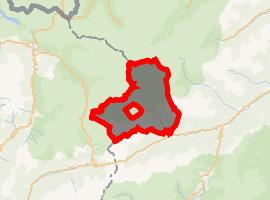 | |
) Peio Location of Peio in Italy ) Peio Peio (Trentino-Alto Adige/Südtirol) | |
| Coordinates: 46°22′N 10°40′E / 46.367°N 10.667°E | |
| Country | Italy |
| Region | Trentino-Alto Adige/Südtirol |
| Province | Trentino (TN) |
| Area | |
| • Total | 162.3 km2 (62.7 sq mi) |
| Elevation | 1,612 m (5,289 ft) |
| Population (Aug. 2016)[2] | |
| • Total | 1,845 |
| • Density | 11/km2 (29/sq mi) |
| Demonym(s) | Pegaési |
| Time zone | UTC+1 (CET) |
| • Summer (DST) | UTC+2 (CEST) |
| Postal code | 38024 |
| Dialing code | 0463 |
| Website | Official website |
Peio (Péj in local dialect) is a comune (municipality) in Trentino in the northern Italian region Trentino-Alto Adige/Südtirol, located about 80 kilometres (50 mi) northwest of Trento. As of 31 December 2004, it had a population of 1,892 and an area of 162.3 square kilometres (62.7 sq mi).[3]
Peio borders the following municipalities: Martell, Valfurva, Rabbi, Ponte di Legno, Vermiglio, Ossana and Pellizzano.
History
Until the end of World War I (1918) Peio, as the whole region, was part of the Austro-Hungarian Empire; the border between the Empire and the Kingdom of Italy was in the mountains over Peio, where a hard war took place, among cliffs, snow and glaciers. Even today, thanks to the melting of glaciers, can be found pieces of army equipment. A small museum in Peio shows them, together with filmed documents of those battles.
Peio was, till recent decades, a hamlet in the mountains, which sustained itself on agriculture and cattle raising. Since 1970 a rapid development began, making Peio a ski resort and a centre dedicated to wellness. Peio valley is rich in mineral waters, which now are exploited not only to produce bottled water but also for therapeutic purposes.
Another important factor of Peio's touristic development is its location in Stelvio National Park, a vast mountain zone where vegetal and animal biodiversity is strictly preserved. Easy walks and more difficult trekking routes allow visitors to explore valleys and woodlands from Passo del Tonale to Ortles.
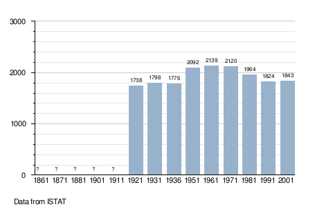
Demographic evolution
References
- ^ "Superficie di Comuni Province e Regioni italiane al 9 ottobre 2011". Istat. Retrieved 16 March 2019.
- ^ "Popolazione Residente al 1° Gennaio 2018". Istat. Retrieved 16 March 2019.
- ^ All demographics and other statistics: Italian statistical institute Istat.
External links
- (in Italian) Homepage of the city