Parenty | |
|---|---|
) The town hall and school of Parenty | |
) Coat of arms | |
Location of Parenty 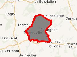 | |
) Parenty ) Parenty | |
| Coordinates: 50°35′19″N 1°48′36″E / 50.5886°N 1.81°E | |
| Country | France |
| Region | Hauts-de-France |
| Department | Pas-de-Calais |
| Arrondissement | Montreuil |
| Canton | Lumbres |
| Intercommunality | CC Haut Pays du Montreuillois |
| Government | |
| • Mayor (2020–2026) | Serge Depraiter |
| Area 1 | 12.92 km2 (4.99 sq mi) |
| Population (Jan. 2017)[1] | 520 |
| • Density | 40/km2 (100/sq mi) |
| Time zone | UTC+01:00 (CET) |
| • Summer (DST) | UTC+02:00 (CEST) |
| INSEE/Postal code | 62648 /62650 |
| Elevation | 50–194 m (164–636 ft) (avg. 77 m or 253 ft) |
| 1 French Land Register data, which excludes lakes, ponds, glaciers > 1 km2 (0.386 sq mi or 247 acres) and river estuaries. | |
Parenty is a commune in the Pas-de-Calais department in the Hauts-de-France region of France.
Geography
Parenty lies about 10 miles (16 km) north of Montreuil-sur-Mer, on the D127.
Population
| Year | Pop. | ±% p.a. |
|---|---|---|
| 1968 | 406 | — |
| 1975 | 378 | −1.02% |
| 1982 | 369 | −0.34% |
| 1990 | 349 | −0.69% |
| 1999 | 396 | +1.41% |
| 2007 | 417 | +0.65% |
| 2012 | 528 | +4.83% |
| 2017 | 520 | −0.30% |
| Source: INSEE[2] | ||
Places of interest
- Vestiges of a Merovingian cemetery
- The Château, dated 1785
- Manorhouse of Parenty
- Manorhouse at Hodicq
- Manorhouse at Annezy
- A feudal motte
- Chapel of Saint-Eloi at Herimetz.
- The sixteenth century church of St. Wulmer
See also
References
- ^ "Populations légales 2017". INSEE. Retrieved 6 January 2020.
- ^ Population en historique depuis 1968, INSEE