Oberteuringen | |
|---|---|
) Coat of arms | |
Location of Oberteuringen within Bodenseekreis district 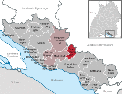 | |
) Oberteuringen ) Oberteuringen | |
| Coordinates: 47°43′30″N 09°28′15″E / 47.72500°N 9.47083°E | |
| Country | Germany |
| State | Baden-Württemberg |
| Admin. region | Tübingen |
| District | Bodenseekreis |
| Government | |
| • Mayor | Ralf Meßmer (Ind.) |
| Area | |
| • Total | 20.06 km2 (7.75 sq mi) |
| Elevation | 451 m (1,480 ft) |
| Population (2019-12-31)[1] | |
| • Total | 5,012 |
| • Density | 250/km2 (650/sq mi) |
| Time zone | UTC+01:00 (CET) |
| • Summer (DST) | UTC+02:00 (CEST) |
| Postal codes | 88094 |
| Dialling codes | 07546 |
| Vehicle registration | FN |
| Website | www.oberteuringen.de |
Oberteuringen is a town in the district of Bodensee in Baden-Württemberg, south-west Germany.
It lies some 8 km north of the Bodensee (Lake Constance) and 4 km east of Mount Gehrenberg. Nearby towns are Markdorf (6 km), Friedrichshafen (7 km), Tettnang (11 km), and Ravensburg (12 km).
The Oberteuringen council district includes the villages of Bibruck, Bitzenhofen, Hefigkofen, Neuhaus, Rammetshofen, Remette, Unterteuringen, and Vittenhaag.
References
- ^ "Bevölkerung nach Nationalität und Geschlecht am 31. Dezember 2019". Statistisches Landesamt Baden-Württemberg (in German). September 2020.