Nijkerk | |
|---|---|
Municipality | |
) Aerial view of Nijkerk | |
) Flag Coat of arms | |
.svg.gif')) Location in Gelderland | |
| Coordinates: 52°14′N 5°29′E / 52.233°N 5.483°E | |
| Country | Netherlands |
| Province | Gelderland |
| Government | |
| • Body | Municipal council |
| • Mayor | Gerard Renkema (CDA) |
| Area | |
| • Total | 72.04 km2 (27.81 sq mi) |
| • Land | 69.34 km2 (26.77 sq mi) |
| • Water | 2.70 km2 (1.04 sq mi) |
| Elevation | 1 m (3 ft) |
| Population (January 2019)[4] | |
| • Total | 42,943 |
| • Density | 619/km2 (1,600/sq mi) |
| Demonym(s) | Nijkerker |
| Time zone | UTC+1 (CET) |
| • Summer (DST) | UTC+2 (CEST) |
| Postcode | 3860–3871 |
| Area code | 033 |
| Website | www |
Nijkerk (Dutch pronunciation: [ˈnɛi̯kɛr(ə)k] ; Dutch Low Saxon: Niekark) is a municipality and a city located in the middle of the Netherlands, in the province of Gelderland.
Population centres
Some people state that Groot Corlaer is a population centre on his own, but officially it's part of the city of Nijkerk
Transportation
Railway station: Nijkerk
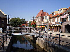
The city of Nijkerk
)
The name Nijkerk stems from Nieuwe Kerk (Dutch for New Church). This new church was built after the old chapel had been destroyed by fire in 1221. Nijkerk was strategically located between the Duchy of Guelders (Dutch: Hertogdom Gelre) and the Bishopric of Utrecht. Because of this strategic location Nijkerk regularly was the scene of war, and in 1412 the village was completely destroyed. It was restored and Nijkerk received city rights in 1413. In 1421 the church that gave Nijkerk its name burnt down and was replaced; this happened several times, until a new church was built in the 18th century which still stands today. The organ in this church was built in 1756.
In the 18th century Nijkerk was a flourishing merchant city. Several inhabitants traveled to the New World, such as Arent van Curler and Kiliaen van Rensselaer and founded new cities.
Since World War II, Nijkerk has been growing fast. It is situated on the (former) shore of the IJsselmeer, which allows for transportation of goods via ships, and in the proximity of two major motorways, the E30 (A1) and E232 (A28). This allowed local industries to grow, and also encouraged a lot of people who work in the nearby Randstad to move to the more rural and peaceful town of Nijkerk. The easy access to the Veluwe is also a contributing factor to this growth.
Politics
In 2000, the municipalities of Nijkerk and Hoevelaken merged to form the new municipality of Nijkerk. On August 24, 2011, the municipality announced that Nijkerk had passed the mark of 40,000 inhabitants. The city council was consequently expanded to 27 seats for the 2014 election.[5]
Currently (March, 2020) the seats are divided as follows:
| Party | Number of seats |
|---|---|
| CDA | 8 |
| Christian Union and SGP | 6 |
| VVD | 4 |
| Progressief 21 | 5 |
| Lokale Partij | 4 |
Progressief 21 is a local party combining the local chapters of the Democrats 66, GroenLinks and the Labour Party. The last two parties are local parties that have no national connection.
Geography
Climate
| Climate data for Nijkerk | |||||||||||||
|---|---|---|---|---|---|---|---|---|---|---|---|---|---|
| Month | Jan | Feb | Mar | Apr | May | Jun | Jul | Aug | Sep | Oct | Nov | Dec | Year |
| Record high °C (°F) | 14.9 (58.8) | 18.9 (66.0) | 25.4 (77.7) | 29.2 (84.6) | 31.5 (88.7) | 33.9 (93.0) | 37.5 (99.5) | 36.1 (97.0) | 29.6 (85.3) | 26.9 (80.4) | 19.0 (66.2) | 15.3 (59.5) | 37.5 (99.5) |
| Average high °C (°F) | 5.5 (41.9) | 6.0 (42.8) | 9.5 (49.1) | 13.5 (56.3) | 18.0 (64.4) | 20.0 (68.0) | 22.5 (72.5) | 22.5 (72.5) | 19.0 (66.2) | 14.5 (58.1) | 9.5 (49.1) | 6.0 (42.8) | 13.9 (57.0) |
| Average low °C (°F) | 0.0 (32.0) | 0.0 (32.0) | 2.0 (35.6) | 4.0 (39.2) | 8.0 (46.4) | 10.5 (50.9) | 13.0 (55.4) | 12.5 (54.5) | 10.0 (50.0) | 7.0 (44.6) | 3.5 (38.3) | 1.0 (33.8) | 6.0 (42.7) |
| Record low °C (°F) | −20.3 (−4.5) | −21.9 (−7.4) | −16.9 (1.6) | −8.4 (16.9) | −2.9 (26.8) | −0.4 (31.3) | 2.5 (36.5) | 2.9 (37.2) | −2.2 (28.0) | −7.4 (18.7) | −11.2 (11.8) | −15.5 (4.1) | −21.9 (−7.4) |
| Average precipitation mm (inches) | 75 (3.0) | 55 (2.2) | 75 (3.0) | 45 (1.8) | 65 (2.6) | 70 (2.8) | 80 (3.1) | 80 (3.1) | 75 (3.0) | 80 (3.1) | 85 (3.3) | 85 (3.3) | 870 (34.3) |
| Mean monthly sunshine hours | 60 | 85 | 125 | 175 | 210 | 195 | 205 | 190 | 140 | 110 | 60 | 50 | 1,605 |
| Source 1: [6] | |||||||||||||
| Source 2: [7] | |||||||||||||
Notable residents
)
- Kiliaen van Rensselaer (1586 in Hasselt - ca.1642), merchant and Hudson Valley patroon
- Wouter van Twiller (1606 in Nijkerk – 1654) the Director of New Netherland 1632 to 1638.
- Arent van Curler (1619 in Nijkerk - 1667), founder of Schenectady, New York
- Johann Frederik Eijkman (1851 in Nijkerk – 1915) a Dutch chemist
- James Kwast (1852 in Nijkerk - 1927), pianist and teacher
- Christiaan Eijkman (1858 in Nijkerk - 1930) a Dutch physician and professor of physiology, received the Nobel Prize for Physiology or Medicine in 1929 for the discovery of vitamins
- Jakob van Domselaer (1890 in Nijkerk – 1960) a composer, part of De Stijl with Piet Mondrian
- Bernardus Johannes Alfrink (1900 in Nijkerk - 1987), Cardinal, Roman Catholic Archdiocese of Utrecht
- Henri Nouwen (1932 in Nijkerk - 1996) a Catholic priest, professor, writer and theologian
- Kees de Kort (born 1934 in Nijkerk) an artist, illustrates Bible scenes for children's books.
- Norbert Klein (born 1956) a Dutch politician, lives in Hoevelaken
- Levi van Veluw (born 1985 in Hoevelaken) a Dutch contemporary artist using photographs, videos and sculptures
Sport
- Brigitte van der Lans (born 1968 in Hoevelaken) a Dutch former backstroke swimmer, competed at the 1984 Summer Olympics
- Bram van Polen (born 1985 in Nijkerk) a Dutch footballer, 385 caps with PEC Zwolle
- Scott Deroue (born 1995 in Nijkerkerveen) a Dutch motorcycle racer.
- Donny van de Beek (born 1997 in Nijkerkerveen) a Dutch professional footballer.
Twin town
Nijkerk is twinned with
|
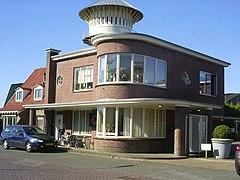
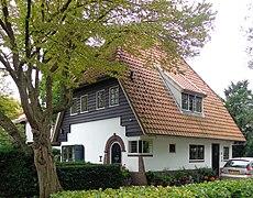
Gallery
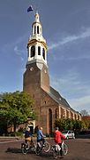
The Grote Kerk (Nijkerk)
.jpg)
Arkervaart (kanaal)
Driedorp NH-kerk
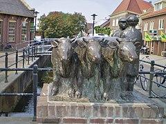
Nijkerk Handelende boeren met koeien
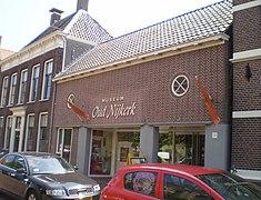
Nijkerk museum Oud Nijkerk
Grêft yn Nijkerk
Nijkerk-westkadijk
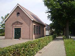
Hoevelaken Park Weldam

Slûs Nijkerkernau
)
.jpg'))
)
)
)
)
)
)
)
References
- ^ "Burgemeester Gerard Renkema" [Mayor Gerard Renkema] (in Dutch). Gemeente Nijkerk. Archived from the original on 14 July 2014. Retrieved 11 July 2014.
- ^ "Kerncijfers wijken en buurten 2020" [Key figures for neighbourhoods 2020]. StatLine (in Dutch). CBS. 24 July 2020. Retrieved 19 September 2020.
- ^ "Postcodetool for 3861AK". Actueel Hoogtebestand Nederland (in Dutch). Het Waterschapshuis. Retrieved 11 July 2014.
- ^ "Bevolkingsontwikkeling; regio per maand" [Population growth; regions per month]. CBS Statline (in Dutch). CBS. 1 January 2019. Retrieved 1 January 2019.
- ^ [1]
- ^ "Klimaatatlas". knmi.nl. Retrieved 2015-03-08.
- ^ "Extremen KNMI-station Soesterberg (until 2008 - after 2008, extremes have been recorded at nearby De Bilt weather station)". weergegevens.nl. Retrieved 2015-03-09.
External links
 Media related to Nijkerk at Wikimedia Commons
- Official website