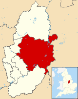
District of Newark and Sherwood | |
|---|---|
District | |
 Shown within Nottinghamshire | |
| Sovereign state | United Kingdom |
| Constituent country | England |
| Region | East Midlands |
| Administrative county | Nottinghamshire |
| Admin. HQ | Newark-on-Trent[1] |
| Government | |
| • Type | Newark and Sherwood District Council |
| • Leadership: | Leader and committee system |
| • Executive: | Conservative |
| • MPs: | Robert Jenrick, Mark Spencer |
| Area | |
| • Total | 251.5 sq mi (651.3 km2) |
| Area rank | 61st |
| Population (mid-2019 est.) | |
| • Total | 122,421 |
| • Rank | Ranked 190th |
| • Density | 490/sq mi (190/km2) |
| Time zone | UTC+0 (Greenwich Mean Time) |
| • Summer (DST) | UTC+1 (British Summer Time) |
| ONS code | 37UG (ONS) E07000175 (GSS) |
| Ethnicity | 98.5% White |
| Website | www |
Newark and Sherwood is a local government district and is the largest district in Nottinghamshire, England. The district was formed on 1 April 1974, by a merger of the municipal borough of Newark with Newark Rural District and Southwell Rural District. It was originally known just as Newark: the name was changed by the council effective 1 April 1995.
The district is predominantly rural, with some large forestry plantations, the ancient Sherwood Forest and the towns of Newark-on-Trent, Southwell and Ollerton.
Settlements
Many settlements in the west of the district, such as Ollerton are former coal mining villages. Southwell is a small Georgian town with a Minster. The south-eastern settlements are home to many people who commute into Nottingham for work. Newark-on-Trent, together with Balderton, forms the largest urban concentration. Newark-on-Trent has many important historic features including Newark Castle, Georgian architecture and a defensive earthwork from the British Civil Wars. Other settlements in the district include:
- Averham
- Balderton, Bathley, Bilsthorpe, Blidworth, Boughton, Brough
- Carlton-on-Trent, Caunton, Clipstone, Collingham, Cromwell
- Eakring, Edingley, Edwinstowe, Egmanton
- Farndon, Farnsfield, Fernwood, Fiskerton
- Gunthorpe
- Halam, Halloughton, Hawton, Hockerton
- Kelham, Kirklington, Kirton, Kneesall
- Laxton, Little Carlton, Lowdham
- Maplebeck, Morton
- North Muskham, Norwell
- Ossington, Oxton
- Perlethorpe
- Rainworth, Rolleston
- South Muskham, Sutton-on-Trent
- Thurgarton
- Upton
- Walesby, Wellow, Weston, Winkburn
References
- ^ "Castle House". newark-sherwooddc.gov.uk. Newark and Sherwood District Council. Archived from the original on 14 June 2020. Retrieved 14 June 2020.
