| ||||
|---|---|---|---|---|
| Day Lane | ||||
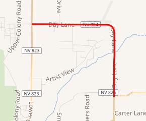 SR 824 highlighted in red | ||||
| Route information | ||||
| Maintained by NDOT | ||||
| Length | 5.560 mi[1] (8.948 km) | |||
| Major junctions | ||||
| South end | ||||
| North end | ||||
| Highway system | ||||
| ||||
)
State Route 824 (SR 824) is a state highway in Lyon County, Nevada, United States. It runs from State Route 208 (Topaz–Yerington Road) near Smith north and west to State Route 823 (Lower Colony Road).
_in_Lyon_County,_Nevada.jpg'))
View at the south end of SR 824 looking northbound
Major intersections
The entire route is in Lyon County.
| Location | mi[1] | km | Destinations | Notes | |
|---|---|---|---|---|---|
| | 0.000 | 0.000 | |||
| Smith Valley | 5.560 | 8.948 | |||
| 1.000 mi = 1.609 km; 1.000 km = 0.621 mi | |||||
References
- ^ a b Nevada Department of Transportation (January 2017). "State Maintained Highways of Nevada: Descriptions and Maps". Retrieved 2017-01-12.