| ||||
|---|---|---|---|---|
| Waltham Way | ||||
 SR 655 highlighted in red | ||||
| Route information | ||||
| Maintained by NDOT | ||||
| Length | 1.138 mi[1] (1.831 km) | |||
| Highway system | ||||
| ||||
)
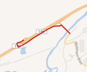
State Route 655 (SR 655) is a state highway in Nevada. It begins at ramps 3 and 4 of the Patrick Interchange (exit 28) on Interstate 80 in Washoe County, running along old frontage roads 13 and 14 east and south to a bridge over the Truckee River into Storey County. SR 655 ends 0.054 miles into Storey County.
Route 655 is also known as Waltham Way.
_near_Interstate_80_in_Washoe_County,_Nevada.jpg'))
View south along SR 655
Major intersections
| County | Location | mi | km | Destinations | Notes |
|---|---|---|---|---|---|
| Washoe | | 0.000 | 0.000 | ||
| Storey | 1.138 | 1.831 | Waltham Way | Continuation past eastern end | |
| 1.000 mi = 1.609 km; 1.000 km = 0.621 mi | |||||
References
- ^ Nevada Department of Transportation (January 2017). "State Maintained Highways of Nevada: Descriptions and Maps". Retrieved 2017-01-22.