| ||||
|---|---|---|---|---|
| Caselton Mine Loop | ||||
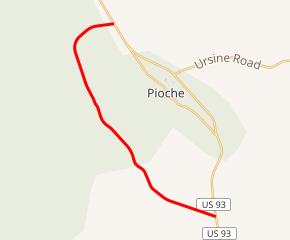 SR 320 highlighted in red | ||||
| Route information | ||||
| Maintained by NDOT | ||||
| Length | 10.674 mi[1] (17.178 km) | |||
| Existed | 1976–present | |||
| Major junctions | ||||
| Southeast end | ||||
| Northwest end | ||||
| Highway system | ||||
| ||||
)
State Route 320 (SR 320) is a state highway in Lincoln County, Nevada, United States. Known as the Caselton Mine Loop, the highway is a loop route of U.S. Route 93 (US 93) near Pioche serving the Caselton Mining District.
)
View from the north end of SR 320 looking southbound
Major intersections
The entire route is in Lincoln County.
| Location | mi | km | Destinations | Notes | |
|---|---|---|---|---|---|
| | 0.000 | 0.000 | |||
| | 10.674 | 17.178 | |||
| 1.000 mi = 1.609 km; 1.000 km = 0.621 mi | |||||
References
- ^ Nevada Department of Transportation (January 2017). "State Maintained Highways of Nevada: Descriptions and Maps". Retrieved 2017-04-14.