Nasarawa | |
|---|---|
| Nickname(s): | |
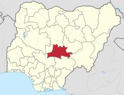 Location of Nasarawa State in Nigeria | |
| Coordinates: 8°32′N 8°18′E / 8.533°N 8.300°E | |
| Country | |
| Date created | 1 October 1996 |
| Capital | Lafia |
| Government | |
| • Governor[2] | Abdullahi Sule |
| • Deputy Governor | Dr. Emmanuel Akabe |
| • Representatives | List |
| Area | |
| • Total | 27,117 km2 (10,470 sq mi) |
| Population (2006) | |
| • Total | 1,869,377[1] |
| GDP (PPP) | |
| • Year | 2007 |
| • Total | $3.02 billion[3] |
| • Per capita | $1,588[3] |
| Time zone | UTC+01 (WAT) |
| ISO 3166 code | NG-NA |
| HDI (2018) | 0.574[4] medium · 19th of 37 |
| Website | www |
Nasarawa is a state in north central geopolitical zone in Nigeria. Its capital is Lafia.
History
Nasarawa was created on 1 October 1996 by the Abacha government from the (today neighboring) Plateau State.[5]
Geography
Nasarawa State is bounded in the north by Kaduna State, in the west by the Federal Capital Territory, in the south by Kogi and Benue States and in the east by Taraba and Plateau States.
A network of roads exist within the state, linking all rural areas and major towns. The Nigerian Railway Corporation (NRC) operates train services from Kuru, Gombe and Maiduguri.
Government
The Governor of Nasarawa State is the executive. The state legislature, Nasarawa State House of Assembly, is located in Lafia.
Local Government Areas
The State has three National Senatorial Districts (South, North and West).
Nasarawa State consists of thirteen (13) Local Government Areas (shown with 2006 population figures[6]):
| Nasarawa West Senatorial District | 716,802 |
|---|---|
| Karu | 205,477 |
| Keffi | 92,664 |
| Kokona | 109,749 |
| Nasarawa | 189,835 |
| Toto | 119,077 |
| Nasarawa North Senatorial District | 335,453 |
| Akwanga | 113,430 |
| Eggon | 149,129 |
| Wamba | 72,894 |
| Nasarawa South Senatorial District | 811,020 |
| Awe | 112,574 |
| Doma | 139,607 |
| Keana | 79,253 |
| Lafia | 330,712 |
| Obi | 148,874 |
List of current Local Government Area Chairmen.[7]
Languages
Languages of Nasarawa State listed by LGA:[8]
| LGA | Languages | |||
|---|---|---|---|---|
| Akwanga | Duhwa; Eggon; Fulani; Gwandara; Hausa; Mada; Mama; Ninzo; Numana; Nungu | |||
| Awe | Hausa; Fulani; Gwandara; Eggon; Goemai; Lijili; Tiv; Wapan | |||
| Doma | Alago; Eggon; Tiv; Agatu; Fulani; Hausa; | |||
| Karu | Ashe; Duya; Eggon; Gade; Nyankpa | |||
| Keana | Alago; Gwandara;Eggon; Tiv; Fulani | Keffi | Hausa; Fulani; Gade; Eggon;Gbagyi; Gwandara; Koro Wachi | |
| Kokona | Gwandara; Fulani; Hausa; Eggon | |||
| Lafia | Bare-Bari; Hausa; Fulani; Ake; Alago; Agatu; Eggon; Goemai; Gwandara; Kofyar; Lijili; Tiv; Wapan | |||
| Nasarawa | Hausa; Fulani; Agatu; Alago; Basa; Egbura; Eloyi; Gade; Gbagyi; Gwandara; Eggon; Tiv | |||
| Nasarawa-Eggon | Eggon; Mada; Nungu; Fulani; Hausa | |||
| Obi | Alago; Hausa; Fulani; Eggon; Tiv | |||
| Toto | Egbura Agatu; Eggon; Gade; Fulani; Hausa | |||
| Wamba | Alumu-Tesu; Bu; Eggon; Hasha; Fulani; Kantana; Nungu; Toro |
Economy
Nasarawa State has agriculture as the mainstay of its economy with the production of varieties of cash crops throughout the year. It also contains various minerals such as salt, baryte, and bauxite, which are mostly mined by artisanal miners.
Education
The state has a College of Education in Akwanga, Federal Polytechnic Nasarawa, College of Agriculture in Lafia, Isa Mustapha Agwai I Polytechnic Lafia, Nasarawa State University Faculty of Agriculture Lafia Camous, a newly established Federal University of Lafia, Mewar University at Masaka, Bingham University at Karu, NACAP polytechnic Akwanga, Command secondary school Lafia, Command secondary school Rinze, Vocational And Relevant technology board, and many primary and secondary schools.
Tourism
Nasarawa State is home to the Farin Ruwa Falls in Wamba Local Government area of the state. Farin Ruwa falls is reputed to be one of the highest falls in Africa.[9]
There is also the Salt Village in Keana Local Government Area of the State. It produces naturally iodized salt from the lake located near it. The town is also one of the cradles of Alago civilization, one of the major ethnic groups in the state.
Another tourist site in Nasarawa State is the Maloney Hill.[10]
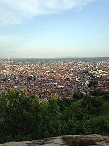
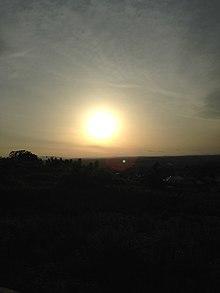
Here is a view of keffi town and a beautiful sunset at Maloney Hill.
Notable people
- Imaan Sulaiman-Ibrahim – Director-General of NAPTIP
References
- ^ "2006 PHC Priority Tables – National Population Commission". population.gov.ng. Archived from the original on 2017-10-10. Retrieved 2017-10-10.
- ^ See List of Governors of Nasarawa State for a list of prior governors
- ^ a b "C-GIDD (Canback Global Income Distribution Database)". Canback Dangel. Retrieved 2008-08-20.
- ^ "Sub-national HDI - Area Database - Global Data Lab". hdi.globaldatalab.org. Retrieved 2018-09-13.
- ^ Nassarawa State University, Keffi (NSUK), is a tertiary institution which was created to encourage the advancement of learning in the state and its neighbouring environment. NSUK was established under the Nasarawa State Law No. 2 of 2001 as passed by the State House of Assembly under the first democratically elected Governor of Nasarawa State, Governor (Dr.) Abdullahi Adamu but was born and sited in February 2002, at the defunct College of Arts, Science and Technology (CAST), Keffi. It was established with the fundamental aim of providing an avenue for Nassarawa State indigenes to pursue and acquire tertiary education. Located in Keffi town. Nassarawa State University caters for both full time and part-time students. Brief Data
- ^ 2006 Population Census, Federal Republic of Nigeria, National Bureau of Statistics. Archived from the original on 2009-03-25.
- ^ "Archived copy". Archived from the original on 2015-01-18. Retrieved 2015-01-18.
- ^ "Nigeria". Ethnologue (22 ed.). Retrieved 2020-01-10.
- ^ Dreaming of Farin Ruwa | GlobalPost
- ^ "Mission to Maloney Hill". The Nation Newspaper. The Nation. The Nation. 8 November 2012.

