.svg.gif'))
)
Quintana Roo is a state in Southeast Mexico divided into eleven municipalities. According to the 2020 Mexican Census, it has the twenty-forth largest population of all states with 1,857,985 inhabitants and the 19th largest by land area spanning 44,705.2 square kilometres (17,260.8 sq mi).[1][2]
Municipalities in Quintana Roo are administratively autonomous of the state according to the 115th article of the 1917 Constitution of Mexico.[3] Every three years, citizens elect a municipal president (Spanish: presidente municipal) by a plurality voting system who heads a concurrently elected municipal council (ayuntamiento) responsible for providing all the public services for their constituents. The municipal council consists of a variable number of trustees and councillors (regidores y síndicos).[4] Municipalities are responsible for public services (such as water and sewerage), street lighting, public safety, traffic, supervision of slaughterhouses and the maintenance of public parks, gardens and cemeteries.[5] They may also assist the state and federal governments in education, emergency fire and medical services, environmental protection and maintenance of monuments and historical landmarks. Since 1984, they have had the power to collect property taxes and user fees, although more funds are obtained from the state and federal governments than from their own income.[5]
The largest municipality by population is Benito Juárez, with 911,503 residents while the smallest is Isla Mujeres with 22,686 residents.[1] The largest municipality by land area is Felipe Carrillo Puerto which spans 12,939.30 km2 (4,995.89 sq mi), and the smallest is Cozumel with 488.00 km2 (188.42 sq mi).[2]
The state was established out of the Quintana Roo Territory in 1974 with seven municipios. The newest municipalities are: Solidaridad, separated in 1993 from Cozumel by act of the Congress of Quintana Roo; Tulum, split off from Solidaridad in March 2008;[6] Bacalar, carved from Othón P. Blanco in 2011;[7] and Puerto Morelos, created out of Benito Juárez in 2016.
Municipalities
- Largest municipalities in Quintana Roo by population
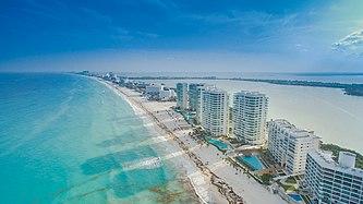
Benito Juárez, largest municipality by population in Quintana Roo.
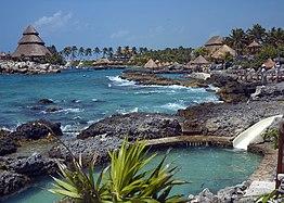
Solidaridad, second largest municipality by population.
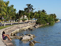
Othón P. Blanco, third largest municipality by population.
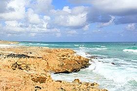
Cozumel, fourth largest municipality by population.
)
)
![]() State capital
State capital
| Name | Municipal seat | Population (2020)[1] | Population (2010)[8] | Change | Land area[2] | Population density (2020) | Incorporation date[9] | |
|---|---|---|---|---|---|---|---|---|
| km2 | sq mi | |||||||
| Bacalar[a] | Bacalar | 41,754 | 32,759 | +27.5% | 6,058.5 | 2,339.2 | 6.9/km2 (17.8/sq mi) | February 2, 2011 |
| Benito Juárez | Cancún | 911,503 | 661,176 | +37.9% | 930.7 | 359.3 | 979.4/km2 (2,536.6/sq mi) | January 12, 1975 |
| Cozumel | San Miguel de Cozumel | 88,626 | 79,535 | +11.4% | 488.0 | 188.4 | 181.6/km2 (470.4/sq mi) | April 21, 1862 |
| Felipe Carrillo Puerto[b] | Felipe Carrillo Puerto | 83,990 | 75,026 | +11.9% | 12,938.3 | 4,995.5 | 6.5/km2 (16.8/sq mi) | February 27, 1904 |
| Isla Mujeres | Isla Mujeres | 22,686 | 16,203 | +40.0% | 862.5 | 333.0 | 26.3/km2 (68.1/sq mi) | July 24, 1867 |
| José María Morelos | José María Morelos | 39,165 | 36,179 | +8.3% | 4,850.0 | 1,872.6 | 8.1/km2 (20.9/sq mi) | January 12, 1975 |
| Lázaro Cárdenas | Kantunilkín | 29,171 | 25,333 | +15.2% | 3,593.3 | 1,387.4 | 8.1/km2 (21.0/sq mi) | January 12, 1975 |
| Othón P. Blanco[c] | Chetumal | 233,648 | 244,553 | −4.5% | 9,909.8 | 3,826.2 | 23.6/km2 (61.1/sq mi) | February 27, 1904 |
| Puerto Morelos | Puerto Morelos | 26,921 | 15,725 | +71.2% | 1,040.5 | 401.7 | 25.9/km2 (67.0/sq mi) | January 6, 2016 |
| Solidaridad | Playa del Carmen | 333,800 | 159,310 | +109.5% | 2,014.9 | 778.0 | 165.7/km2 (429.1/sq mi) | July 28, 1993 |
| Tulum | Tulum | 46,721 | 28,263 | +65.3% | 2,018.6 | 779.4 | 23.1/km2 (59.9/sq mi) | March 13, 2008[6] |
| Quintana Roo | — | 1,857,985 | 1,325,578 | +40.2% | 44,705.2 | 17,260.8 | 41.6/km2 (107.6/sq mi) | — |
| Mexico | — | 126,014,024 | 112,336,538 | +12.2% | 1,960,646.7 | 757,010 | 64.3/km2 (166.5/sq mi) | — |
Notes
References
- ^ a b c "Censo de Población y Vivienda 2020 - SCITEL" (in Spanish). INEGI. Retrieved 2021-01-27.
- ^ a b c "México en cifras - Medio Ambiente - Quintana Roo" (in Spanish). INEGI. Retrieved February 12, 2021.
- ^ "Constitución Política de los Estados Unidos Mexicanos". Article 115, of 1917 (in Spanish). Retrieved September 27, 2017.
- ^ OECD (November 12, 2004). New Forms of Governance for Economic Development. OECD Publishing. p. 121. ISBN 9264015329.
- ^ a b International Business Publications (2009). Mexico Company Laws and Regulations Handbook. p. 42. ISBN 978-1-4330-7030-3.
- ^ a b "Discuten por nuevo municipio - Riviera Maya" (in Spanish). Archived from the original on 2008-10-09. Retrieved 2011-04-16.
- ^ Silvia Hernández (February 2, 2011). "Bacalar, el décimo municipio de Q. Roo". El Universal. Retrieved 2011-05-02.
- ^ "Censo de Población y Vivienda 2010 - SCITEL" (in Spanish). INEGI. Retrieved 2021-01-27.
- ^ a b c d Estado de Quintana Roo División Territorial de 1810 a 1995 (PDF) (in Spanish). Mexico: INEGI. 1996. ISBN 970-13-1510-3.