Wikipedia

Mount Lamongan

Mount Lamongan
Lamongan.jpg
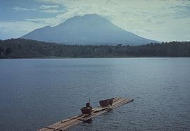
Mount Lamongan from Ranu Klakah, 1985
Highest point
Elevation1,651 m (5,417 ft) [1]
ListingRibu
Coordinates7°58′44″S 113°20′31″E / 7.979°S 113.342°E
Geography
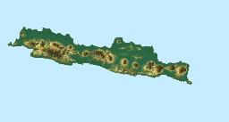
Mount Lamongan is located in Java
Mount Lamongan
Mount Lamongan
Mount Lamongan is located in Indonesia
Mount Lamongan
Mount Lamongan
Mount Lamongan (Indonesia)
Geology
Mountain typeStratovolcano
Last eruptionFebruary 1898

Mount Lamongan or Mount Lemongan is a small stratovolcano located between the massif Tengger caldera complex and Iyang-Argapura volcano complex in East Java, Indonesia. The volcano is surrounded by maars and cinder cones. The volcano's high point is locally named as Gunung Tarub. Lake-filled maars including Ranu Pakis, Ranu Klakah and Ranu Bedali, located on the eastern and western flanks. The northern flanks are dominated by dry maars.[1]

See also

References

  1. ^ a b "Lamongan". Global Volcanism Program. Smithsonian Institution. Retrieved 2006-12-28.
This article is copied from an article on Wikipedia® - the free encyclopedia created and edited by its online user community. The text was not checked or edited by anyone on our staff. Although the vast majority of Wikipedia® encyclopedia articles provide accurate and timely information, please do not assume the accuracy of any particular article. This article is distributed under the terms of GNU Free Documentation License.

Copyright © 2003-2025 Farlex, Inc Disclaimer
All content on this website, including dictionary, thesaurus, literature, geography, and other reference data is for informational purposes only. This information should not be considered complete, up to date, and is not intended to be used in place of a visit, consultation, or advice of a legal, medical, or any other professional.