Montemor-o-Velho | |
|---|---|
 Montemor-o-Velho | |
 | |
| Coordinates: 40°10′N 8°41′W / 40.167°N 8.683°W | |
| Country | |
| Region | Centro |
| Intermunic. comm. | Região de Coimbra |
| District | Coimbra |
| Parishes | 11 |
| Government | |
| • President | Luís Manuel Barbosa Marques Leal (PSD) |
| Area | |
| • Total | 228.96 km2 (88.40 sq mi) |
| Population (2011) | |
| • Total | 26,171 |
| • Density | 110/km2 (300/sq mi) |
| Time zone | UTC±00:00 (WET) |
| • Summer (DST) | UTC+01:00 (WEST) |
| Local holiday | 8 September |
| Website | http://www.cm-montemorvelho.pt/ |
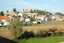
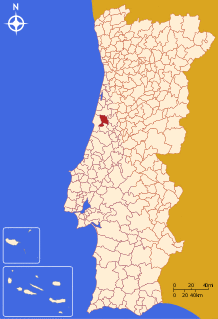
Montemor-o-Velho (Portuguese pronunciation: [mõtɨˈmɔɾ u ˈvɛʎu] ) is a town and municipality of the Coimbra District, in Portugal. The population in 2011 was 26,171,[1] in an area of 228.96 km².[2]
Climate
| Climate data for Montemor-o-Velho, 1971-2000 normals and extremes | |||||||||||||
|---|---|---|---|---|---|---|---|---|---|---|---|---|---|
| Month | Jan | Feb | Mar | Apr | May | Jun | Jul | Aug | Sep | Oct | Nov | Dec | Year |
| Record high °C (°F) | 22.5 (72.5) | 25.3 (77.5) | 28.2 (82.8) | 31.0 (87.8) | 34.5 (94.1) | 40.5 (104.9) | 39.8 (103.6) | 40.3 (104.5) | 38.2 (100.8) | 34.0 (93.2) | 26.4 (79.5) | 22.8 (73.0) | 40.5 (104.9) |
| Average high °C (°F) | 14.5 (58.1) | 15.7 (60.3) | 17.7 (63.9) | 18.7 (65.7) | 20.6 (69.1) | 23.8 (74.8) | 26.1 (79.0) | 26.4 (79.5) | 25.5 (77.9) | 21.9 (71.4) | 17.9 (64.2) | 15.3 (59.5) | 20.3 (68.6) |
| Daily mean °C (°F) | 9.7 (49.5) | 11.0 (51.8) | 12.6 (54.7) | 13.9 (57.0) | 16.1 (61.0) | 18.8 (65.8) | 20.8 (69.4) | 20.7 (69.3) | 19.5 (67.1) | 16.4 (61.5) | 12.8 (55.0) | 10.8 (51.4) | 15.3 (59.5) |
| Average low °C (°F) | 4.8 (40.6) | 6.3 (43.3) | 7.4 (45.3) | 9.0 (48.2) | 11.5 (52.7) | 13.9 (57.0) | 15.4 (59.7) | 15.0 (59.0) | 13.5 (56.3) | 10.9 (51.6) | 7.7 (45.9) | 6.3 (43.3) | 10.1 (50.2) |
| Record low °C (°F) | −6.0 (21.2) | −3.8 (25.2) | −2.6 (27.3) | −0.2 (31.6) | 3.6 (38.5) | 6.6 (43.9) | 9.0 (48.2) | 8.0 (46.4) | 3.0 (37.4) | −2.5 (27.5) | −2.5 (27.5) | −3.8 (25.2) | −6.0 (21.2) |
| Average rainfall mm (inches) | 120.5 (4.74) | 107.4 (4.23) | 64.0 (2.52) | 78.1 (3.07) | 74.5 (2.93) | 31.7 (1.25) | 9.6 (0.38) | 11.9 (0.47) | 43.1 (1.70) | 104.0 (4.09) | 117.1 (4.61) | 128.9 (5.07) | 890.8 (35.06) |
| Average precipitation days (≥ 0.1 mm) | 13.4 | 12.4 | 9.1 | 10.9 | 9.7 | 4.7 | 1.9 | 2.2 | 5.1 | 10.7 | 12.3 | 12.7 | 105.1 |
| Source: Instituto de Meteorologia[3] | |||||||||||||
Demographics
| Population Montemor-o-Velho Municipality (1801–2011) | ||||||||||
|---|---|---|---|---|---|---|---|---|---|---|
| 1801 | 1849 | 1900 | 1930 | 1960 | 1981 | 1991 | 2001 | 2004 | 2006 | 2011 |
| 9528 | 6345 | 22361 | 25162 | 27925 | 27274 | 26375 | 25478 | 25082 | 24950 | 26171 |
Parishes
Administratively, the municipality is divided into 11 civil parishes (freguesias):[4]
- Abrunheira, Verride e Vila Nova da Barca
- Arazede
- Carapinheira
- Ereira
- Gatões e Montemor-o-Velho
- Liceia
- Meãs do Campo
- Pereira
- Santo Varão
- Seixo de Gatões
- Tentúgal
Sports
Montemor-o-Velho has one of the only international sized 2 km rowing lakes in Portugal. The lake hosted its first rowing race in 2002 (the Coupe de la Jeunesse), before it was completed. During the competition, FISA judges noted that the lake was not wide enough to meet international standards. After then, it was rebuilt to meet these standards. It hosted the 2010 European Rowing Championships.[5]
Famous people
- Sesnando Davides, 11th century Mozarab nobleman and general born in Tentúgal, Montemor-o-Velho, who would become governor of the County of Coimbra
- Fernão Mendes Pinto (1509 – 1583), Portuguese explorer and writer
- Lurdes Breda (born 1970), Portuguese writer
Culture
Since 2014, the city hosts the Festival Forte that takes place inside the Montemor-o-Velho Castle in Portugal, during the month of August, with the main focus on electronic music, visual and performing arts.
References
- ^ Instituto Nacional de Estatística
- ^ "Áreas das freguesias, concelhos, distritos e país". Archived from the original on 5 November 2018. Retrieved 5 November 2018.
- ^ "Monthly Averages for Montemor-o-Velho (1971–2000)" (PDF). Instituto de Meteorologia.
- ^ Diário da República. "Law nr. 11-A/2013, page 552 78" (PDF) (in Portuguese). Retrieved 28 July 2014.
- ^ 2010 European Rowing Championships Re-confirmed for Montemor-o-Velho, Portugal Archived 18 June 2010 at the Wayback Machine worldrowing.com accessed 14 June 2010
External links

