| Mogami River 最上川 | |
|---|---|
 | |
| Native name | Mogami-gawa |
| Location | |
| Country | Japan |
| State | Yamagata |
| Physical characteristics | |
| Source | Mount Azuma |
| Mouth | Sea of Japan |
• elevation | 0 m (0 ft) |
| Length | 229 km (142 mi) |
| Basin size | 7,040 km2 (2,720 sq mi) |
| Discharge | |
| • average | 392 m3/s (13,800 cu ft/s) |
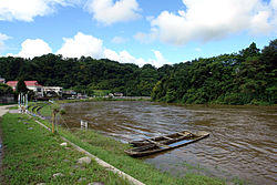
The Mogami River (最上川, Mogami-gawa) is a river in Yamagata Prefecture, Japan.
Description & History
It is 224 km long and has a watershed of 7,040 km². It is regarded as one of the three most rapid rivers of Japan (along with the Fuji River and the Kuma River).
The river rises from southern Yamagata Prefecture and flows to the north, and turns west at Shinjō and flows into the Sea of Japan at Sakata. Water transportation once flourished on the river and carried local products such as safflowers and rice to the Kansai region.
Cultural references
The Mogami River appears as an utamakura in Japanese poetry, with the influential 17th-century poet Matsuo Bashō composing several hokku regarding the river during his travels alongside it.[1][2] Some were revised as haiku in the memoir of his journeys, including this well-known poem:
- 五月雨をあつめて早し最上川
- samidare o atsumete hayashi Mogami-gawa
- gathering the rains
- of the wet season — swift
- the Mogami River
- (trans. Shirane)
The character Yūko Aioi in the Nichijou manga has inner monologues in haiku form, all ending with the name of the river as a complete non sequitur.[3]
Mogami-gawa is also the name of the anthem of Yamagata Prefecture written by Emperor Hirohito. The Japanese Navy had two different cruisers named Mogami.
References
- ^ Shirane, Haruo (1998). Traces of Dreams: Landscape, Cultural Memory, and the Poetry of Bashō. Stanford University Press. pp. 170–173. ISBN 0804730997.
- ^ Greve, Gabi (2012-11-14). "WKD - Matsuo Basho Archives: Oku Station 31 - Sakata". World Kigo Database. Retrieved 2017-06-04.
- ^ Mozzocco, J. Caleb (2016-07-21). "Review: ‘Nichijou,’ vol. 1 — Good Comics for Kids". School Library Journal. Retrieved 2017-06-04.