| ||||
|---|---|---|---|---|
 | ||||
| Route information | ||||
| Maintained by MoDOT | ||||
| Length | 4.28 mi[1] (6.89 km) | |||
| Existed | 1996–present | |||
| Major junctions | ||||
| South end | ||||
| North end | ||||
| Location | ||||
| Counties | Taney, Stone | |||
| Highway system | ||||
| ||||
)
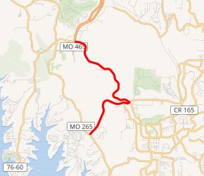
Route 376 is a short highway in Branson, Missouri. Its southern terminus is at Route 265, and its northern terminus is at Route 76.
Route description
In the south, Route 376 begins at Route 265 and heads northeast as a four-lane highway. It proceeds uneventfully through generally rural land until curving towards the northwest. Entering a more developed area of Branson, the highway turns east and passes the Celebration City theme park. After a series of slight north–south curves, it turns left on to 76 Country Blvd. The Route then curves Northwest-Southeast past the Ruth & Paul Henning Conservation Area and the Shepherd of the Hills properties as a two-lane highway. The route ends at a junction with Route 76, at the south end of the Ozark Mountain Highroad. Past the junction at the Highroad, the road continues west as Route 76.[2]
History
Route 376 was designated by 1996.[3] Prior to January of 2020, the highway ended at 76 Country Boulevard, when the road was designated as Route 76. When 76 Country Boulevard east of current Route 376 was turned over to the City of Branson, Route 76 through Branson was rerouted on to the Ozark Mountain Highroad, bypassing the city.[4]
Junction list
| County | Location | mi[1] | km | Destinations | Notes |
|---|---|---|---|---|---|
| Taney | | 0.000 | 0.000 | Southern terminus | |
| Branson | 1.605 | 2.583 | Southern end of Yellow Route concurrency | ||
| 1.739 | 2.799 | Northern end of Yellow Route concurrency; western terminus of Yellow Route; eastern terminus of Red Route | |||
| Stone | | 4.28 | 6.89 | Northern terminus; highway continues as Route 76 west | |
1.000 mi = 1.609 km; 1.000 km = 0.621 mi
| |||||
References
- ^ a b Missouri Department of Transportation (February 8, 2020). MoDOT HPMAPS (Map). Missouri Department of Transportation. Retrieved February 8, 2020.
- ^ Google (March 1, 2010). "Map of Missouri Route 376" (Map). Google Maps. Google. Retrieved March 1, 2010.
- ^ Missouri Official Highway Map 1995-96 (PDF) (Map). Missouri Department of Transportation. Retrieved March 1, 2010.
- ^ "Missouri Route 76 Routing Changes | Missouri Department of Transportation". www.modot.org. Retrieved 2020-02-09.
External links