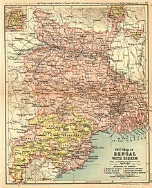
Manbhum District was one of the districts of the East India during the British Raj.[1] After India’s independence, the district became a part of Bihar State. Upon re-organisation of the Indian states in the mid-1950s, present Purulia district was carved out of the district of Manbhum and became a part of the West Bengal; the remaining part of Manbhum district was kept with Bihar state and became part of Dhanbad district.[2]
See also
- Jungle Mahals
- Bengali Language Movement (Manbhum)
References
- ^ Chisholm, Hugh, ed. (1911). . Encyclopædia Britannica. 17 (11th ed.). Cambridge University Press. p. 542.
- ^ Anil (2014-11-05). "History of Manbhum". Anil mandal's blog. Retrieved 2020-01-07.
Further reading
- Coupland, H. Bengal District Gazetteers Manbhum. The Bengal Secretariat Book Depot Calcutta. Retrieved 24 December 2016.
