Wikipedia

Malschwitz

Malschwitz/Malešecy
Malschwitz Church
Malschwitz Church
Coat of arms of Malschwitz/Malešecy
Coat of arms
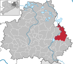
Location of Malschwitz/Malešecy within Bautzen district
Malschwitz in BZ.svg
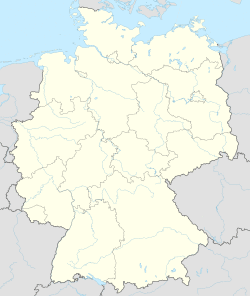
Malschwitz/Malešecy is located in Germany
Malschwitz/Malešecy
Malschwitz/Malešecy
Malschwitz/Malešecy is located in Saxony
Malschwitz/Malešecy
Malschwitz/Malešecy
Coordinates: 51°14′N 14°31′E / 51.233°N 14.517°E
CountryGermany
StateSaxony
DistrictBautzen
Municipal assoc.Malschwitz
Subdivisions14
Government
 • MayorMatthias Seidel (CDU)
Area
 • Total93.21 km2 (35.99 sq mi)
Elevation
150 m (490 ft)
Population
(2019-12-31)[1]
 • Total4,643
 • Density50/km2 (130/sq mi)
Time zoneUTC+01:00 (CET)
 • Summer (DST)UTC+02:00 (CEST)
Postal codes
02694
Dialling codes035932
Vehicle registrationBZ, BIW, HY, KM
Websitewww.malschwitz.de

Malschwitz (Sorbian: Malešecy) is a municipality in the east of Saxony, Germany. It belongs to the district of Bautzen and lies 6 km northeast of the eponymous city.

The municipality is part of the recognized Sorbian settlement area in Saxony. Upper Sorbian has an official status next to German, all villages bear names in both languages.

Geography

The municipality is situated in the Upper Lusatian flatland.

Several villages belong to the municipality:

  • Malschwitz (Malešecy)
  • Pließkowitz (Plusnikecy)
  • Briesing (Brězynka)
  • Niedergurig (Delnja Hórka)
  • Doberschütz (Dobrošecy)
  • Kleinbautzen (Budyšink)
  • Preititz (Přiwćicy)
  • Cannewitz (Skanecy)
  • Rackel (Rakojdy)
  • Baruth bei Bautzen (Bart)
  • Brießnitz (Brězecy)
  • Dubrauke (Dubrawka)
  • Buchwalde (Bukojna)
  • Gleina (Hlina)
  • Brösa (Brězyna)
  • Guttau (Hućina)
  • Halbendorf/Spree (Połpica)
  • Kleinsaubernitz (Zubornička)
  • Lieske (Lěskej)
  • Lömischau (Lemišow)
  • Neudorf/Spree (Nowa Wjes/Sprjewja)
  • Ruhethal (Wotpočink)
  • Wartha (Stróža)

References

  • Trudla Malinkowa/Weldon Mersiovsky (ed.): Malschwitz. Malešecy. A Wendish Village in Lusatia. Serbin 2018, ISBN 978-1-944891-52-7
  1. ^ "Bevölkerung des Freistaates Sachsen nach Gemeinden am 31. Dezember 2019". Statistisches Landesamt des Freistaates Sachsen (in German). July 2020.
This article is copied from an article on Wikipedia® - the free encyclopedia created and edited by its online user community. The text was not checked or edited by anyone on our staff. Although the vast majority of Wikipedia® encyclopedia articles provide accurate and timely information, please do not assume the accuracy of any particular article. This article is distributed under the terms of GNU Free Documentation License.

Copyright © 2003-2025 Farlex, Inc Disclaimer
All content on this website, including dictionary, thesaurus, literature, geography, and other reference data is for informational purposes only. This information should not be considered complete, up to date, and is not intended to be used in place of a visit, consultation, or advice of a legal, medical, or any other professional.