Wikipedia

Long Sault

Passenger vessel Rapids Prince runs the Long Sault Rapids.
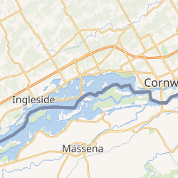
Former location of the Long Sault rapids

Long Sault was a rapid in the St. Lawrence River west of Cornwall.[1]

The Long Sault created a navigation barrier along the river for much of its history, necessitating the construction of the Moses-Saunders Power Dam, part of the St. Lawrence Seaway, in the 1950s as the size of ships and the volume of shipping traffic along the river began to exceed the capacity of the area's canal locks.

The construction required the flooding of a large swath of land near the rapids to facilitate a hydroelectric dam and to make the rapids area more navigable. The flooded region includes Ontario's Lost Villages.

The town of Long Sault, Ontario, and the Long Sault Parkway both take their name from the rapids.

See also

  • Cornwall Canal
  • Eisenhower Lock

References

  1. ^ "Cornwall Canal".


This article is copied from an article on Wikipedia® - the free encyclopedia created and edited by its online user community. The text was not checked or edited by anyone on our staff. Although the vast majority of Wikipedia® encyclopedia articles provide accurate and timely information, please do not assume the accuracy of any particular article. This article is distributed under the terms of GNU Free Documentation License.

Copyright © 2003-2025 Farlex, Inc Disclaimer
All content on this website, including dictionary, thesaurus, literature, geography, and other reference data is for informational purposes only. This information should not be considered complete, up to date, and is not intended to be used in place of a visit, consultation, or advice of a legal, medical, or any other professional.