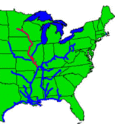
Name Location Miles above the Ohio Coordinates Pool elevation Notes Lake Itasca Stepping Stones / Dam Itasca State Park Lake Itasca Stepping stones placed by CCC with creation of new channel / outlet for Mississippi Vekin's Dam 8 miles north of Lake Itasca n/a Ottertail Power Co. Dam 7 miles east of Bemidji 47°29′1.0032″N 94°43′45.9156″W / 47.483612000°N 94.729421000°W Lake Bemidji Knutson Dam About 15 miles (24 km) east and north of city of Cass Lake 47°27′07″N 94°29′00″W / 47.45194°N 94.48333°W Cass Lake Winnibigoshish Lake Dam About 15 miles (24 km) northwest of Deer River 47°25′44.5″N 94°03′6.8″W / 47.429028°N 94.051889°W Lake Winnibigoshish Owned/operated by U.S. Army Corps of Engineers , Mississippi Valley Division , St. Paul District Pokegama Dam Mile 1187 47°15′2.9844″N 93°35′15.5184″W / 47.250829000°N 93.587644000°W Owned/operated by U.S. Army Corps of Engineers , Mississippi Valley Division , St. Paul District Blandin Paper Co. Dam Mile 1183.6 47°13′54.5628″N 93°31′52.9500″W / 47.231823000°N 93.531375000°W Potlatch Dam Brainerd, Minnesota 46°22′40.8324″N 94°11′0.0816″W / 46.378009000°N 94.183356000°W Rice Lake Little Falls Dam Little Falls, Minnesota 45°58′32″N 94°22′06″W / 45.97556°N 94.36833°W Blanchard Dam Royalton, Minnesota 45°51′39″N 94°21′36″W / 45.86083°N 94.36000°W Sartell Dam Sartell, Minnesota 45°37′15″N 94°12′13″W / 45.62083°N 94.20361°W St. Cloud Dam St. Cloud, Minnesota 45°32′52″N 94°08′50″W / 45.54778°N 94.14722°W Coon Rapids Dam Brooklyn Park / Coon Rapids , Minnesota 45°08′36″N 93°18′43″W / 45.14333°N 93.31194°W No locks, ends navigable portion of river Upper Saint Anthony Falls Lock and Dam Minneapolis, Minnesota ~854 44°58′54″N 93°15′31″W / 44.98167°N 93.25861°W 799 feet Last lock upstream on river. Since June 9, 2015, the lock has remained closed to prevent the spread of invasive Asian Carp .[1] Mississippi National River and Recreation Area . Lower Saint Anthony Falls Lock and Dam Minneapolis, Minnesota ~853 44°58′42″N 93°14′49″W / 44.97833°N 93.24694°W 750 feet Owned/operated by U.S. Army Corps of Engineers , Mississippi Valley Division , St. Paul District Meeker Island Lock and Dam Minneapolis, Minnesota / St. Paul, Minnesota ~850 44°57′14″N 93°12′28″W / 44.95389°N 93.20778°W NA Demolished. Originally known as Lock and Dam No. 2 Lock and Dam No. 1 Minneapolis, Minnesota / St. Paul, Minnesota ~847.8 44°54′55″N 93°12′02″W / 44.91528°N 93.20056°W 725 feet Ford Plant Powerhouse on east side. Owned/operated by U.S. Army Corps of Engineers , Mississippi Valley Division , St. Paul District Lock and Dam No. 2 Hastings, Minnesota ~815 44°45′35″N 92°52′07″W / 44.75972°N 92.86861°W 687 feet Owned/operated by U.S. Army Corps of Engineers , Mississippi Valley Division , St. Paul District Lock and Dam No. 3 Red Wing, Minnesota 796.9 44°36′36″N 92°36′37″W / 44.61000°N 92.61028°W 675 feet Owned/operated by U.S. Army Corps of Engineers , Mississippi Valley Division , St. Paul District Lock and Dam No. 4 Alma, Wisconsin ~753 44°19′32″N 91°55′13″W / 44.32556°N 91.92028°W 667 feet The lock is on the Wisconsin side right next to a small cafe. Owned/operated by U.S. Army Corps of Engineers , Mississippi Valley Division , St. Paul District Lock and Dam No. 5 Winona County, Minnesota ~738.1 44°09′40″N 91°48′39″W / 44.16111°N 91.81083°W 660 feet Visitor parking next to the lock. Owned/operated by U.S. Army Corps of Engineers , Mississippi Valley Division , St. Paul District Lock and Dam No. 5A Goodview, Minnesota ~728.5 44°05′18″N 91°40′08″W / 44.08833°N 91.66889°W 651 feet Owned/operated by U.S. Army Corps of Engineers , Mississippi Valley Division , St. Paul District Lock and Dam No. 6 Trempealeau, Wisconsin ~714.1 43°59′59″N 91°26′18″W / 43.99972°N 91.43833°W 646 feet Owned/operated by U.S. Army Corps of Engineers , Mississippi Valley Division , St. Paul District Lock and Dam No. 7 La Crescent, Minnesota ~702.5 43°52′01″N 91°18′26″W / 43.86694°N 91.30722°W 639 feet Adjacent to I-90 Mississippi River Bridge . Visitor parking and information next to the lock. Owned/operated by U.S. Army Corps of Engineers , Mississippi Valley Division , St. Paul District Lock and Dam No. 8 Genoa, Wisconsin ~679.2 43°34′12″N 91°13′54″W / 43.57000°N 91.23167°W 631 feet Visitor parking right next to the lock. Owned/operated by U.S. Army Corps of Engineers , Mississippi Valley Division , St. Paul District Lock and Dam No. 9 Harpers Ferry, Iowa ~647.9 43°12′46″N 91°06′15″W / 43.21278°N 91.10417°W 620 feet Parking area next to lock on Wisconsin side. Owned/operated by U.S. Army Corps of Engineers , Mississippi Valley Division , St. Paul District Lock and Dam No. 10 Guttenberg, Iowa ~615.0 42°47′06″N 91°05′42″W / 42.78500°N 91.09500°W 611 feet Owned/operated by U.S. Army Corps of Engineers , Mississippi Valley Division , St. Paul District Lock and Dam No. 11 Dubuque, Iowa ~583 42°32′25″N 90°38′39″W / 42.54028°N 90.64417°W 603 feet Owned/operated by U.S. Army Corps of Engineers , Mississippi Valley Division , Rock Island District Iowa –Illinois Lock and Dam No. 12 Bellevue, Iowa ~556.7 42°15′41″N 90°25′12″W / 42.26139°N 90.42000°W 592 feet Owned/operated by U.S. Army Corps of Engineers , Mississippi Valley Division , Rock Island District Lock and Dam No. 13 Fulton, IL ~522.5 41°53′53″N 90°09′21″W / 41.89806°N 90.15583°W 583 feet Owned/operated by U.S. Army Corps of Engineers , Mississippi Valley Division , Rock Island District Lock and Dam No. 14 LeClaire, Iowa ~493.2 41°34′24″N 90°23′56″W / 41.57333°N 90.39889°W 572 feet Owned/operated by U.S. Army Corps of Engineers , Mississippi Valley Division , Rock Island District Lock and Dam No. 15 Rock Island, Illinois ~482.8 41°31′07″N 90°34′08″W / 41.51861°N 90.56889°W 561 feet Owned/operated by U.S. Army Corps of Engineers , Mississippi Valley Division , Rock Island District Lock and Dam No. 16 Muscatine, Iowa ~457.2 41°25′32″N 91°0′35″W / 41.42556°N 91.00972°W 545 feet Owned/operated by U.S. Army Corps of Engineers , Mississippi Valley Division , Rock Island District Lock and Dam No. 17 New Boston, Illinois ~437 41°11′27″N 91°03′37″W / 41.19083°N 91.06028°W 536 feet Owned/operated by U.S. Army Corps of Engineers , Mississippi Valley Division , Rock Island District Lock and Dam No. 18 Gladstone, Illinois ~410.5 40°52′54″N 91°01′27″W / 40.88167°N 91.02417°W 528 feet Owned/operated by U.S. Army Corps of Engineers , Mississippi Valley Division , Rock Island District Lock and Dam No. 19 Keokuk, Iowa ~364 40°23′41″N 91°22′29″W / 40.39472°N 91.37472°W 518 feet Owned/operated by U.S. Army Corps of Engineers , Mississippi Valley Division , Rock Island District Lock and Dam No. 20 Canton, Missouri ~343 40°08′37″N 91°30′46″W / 40.14361°N 91.51278°W 480 feet Owned/operated by U.S. Army Corps of Engineers , Mississippi Valley Division , Rock Island District Lock and Dam No. 21 Quincy, Illinois ~324.9 39°54′23″N 91°25′56″W / 39.90639°N 91.43222°W 470 feet Owned/operated by U.S. Army Corps of Engineers , Mississippi Valley Division , Rock Island District Lock and Dam No. 22 Saverton, Missouri ~301.2 39°38′18″N 91°14′49″W / 39.63833°N 91.24694°W 460 feet Owned/operated by U.S. Army Corps of Engineers , Mississippi Valley Division , Rock Island District Lock and Dam No. 24 Clarksville, Missouri ~273.4 39°22′36″N 90°54′30″W / 39.37667°N 90.90833°W 449 feet Owned/operated by U.S. Army Corps of Engineers , Mississippi Valley Division , St. Louis District Lock and Dam No. 25 Winfield, Missouri ~241.4 39°00′17″N 90°41′11″W / 39.00472°N 90.68639°W 434 feet Owned/operated by U.S. Army Corps of Engineers , Mississippi Valley Division , St. Louis District Lock and Dam No. 26 (historical) Alton, Illinois ~202.5 38°53′10″N 90°10′55″W / 38.88611°N 90.18194°W 419 feet Demolished, replaced by Melvin Price Locks and Dam . Melvin Price Locks and Dam East Alton, Illinois ~200.8 38°52′09″N 90°09′13″W / 38.86917°N 90.15361°W Owned/operated by U.S. Army Corps of Engineers , Mississippi Valley Division , St. Louis District Chain of Rocks Dam Glasgow Village, Missouri ~190.2 38°45′27″N 90°10′39″W / 38.75750°N 90.17750°W 398 feet Owned/operated by U.S. Army Corps of Engineers , Mississippi Valley Division , St. Louis District Chain of Rocks Lock Granite City, Illinois 38°42′11″N 90°10′51″W / 38.70306°N 90.18083°W Owned/operated by U.S. Army Corps of Engineers , Mississippi Valley Division , St. Louis District )
)
)
)
)