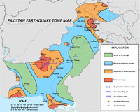
 Earthquake zones of Pakistan. (<6.0 in green, 6.0–6.9 in blue, 7.0–7.9 in orange, 8.0+ in red) | |
| Largest | 8.1 Mw 1945 Balochistan earthquake |
|---|---|
Pakistan is one of the most seismically active countries in the world, being crossed by several major faults. As a result, earthquakes in Pakistan occur often and are destructive.
Geology
Pakistan geologically overlaps both the Eurasian and Indian tectonic plates. Balochistan, the Federally Administered Tribal Areas, Khyber Pakhtunkhwa and Gilgit-Baltistan provinces lie on the southern edge of the Eurasian plate on the Iranian Plateau. Sindh, Punjab and Azad Jammu & Kashmir provinces lie on the north-western edge of the Indian plate in South Asia. Hence this region is prone to violent earthquakes, as the two tectonic plates collide.
Earthquakes
| Date | Locality, district, or province | Mag. | MMI | Deaths | Injuries | Notes | ||
|---|---|---|---|---|---|---|---|---|
| 2021-02-12 | Punjab & Khyber Pakhtunkha | 6.4 Mw | 38 | |||||
| 2019-09-24 | New Mirpur, Azad Kashmir | 5.6 Mw | VII | 40 | 852 | Severe | [1] | |
| 2018-01-30 | Badakhshan | 6.1 Mw | 1 | 9-11 | ||||
| 2015-12-25 | Gilgit-Baltistan Khyber Pakhtunkhwa | 6.3 Mw | V | 4 | 100 | |||
| 2015-10-26 | Badakhshan | 7.5 Mw | VII | 399 | 2,536 | |||
| 2015-07-24 | Islamabad | 5.1 Mw | V | 3 | ||||
| 2014-05-08 | Sindh | 4.5 Mw | 2 | 50 | ||||
| 2013-09-28 | Awaran District, Balochistan | 6.8 Mw | VII | 22 | Aftershock. | |||
| 2013-09-24 | Awaran District, Balochistan | 7.7 Mw | VII | 825 | 700 | |||
| 2013-04-16 | Balochistan | 7.7 Mw | IX | 34 | 105 | |||
| 2011-01-18 | Dalbandin, Balochistan | 7.2 Mw | VI | 3 | some | |||
| 2008-10-29 | Ziarat District, Balochistan | 6.4 Mw | 215 | 200 | ||||
| 2005-10-08 | Azad Kashmir, Balakot | 7.6 Mw | VIII | 86,000–87,351 | 69,000–75,266 | |||
| 1997-02-27 | Balochistan | 7.0 Mw | VIII | 57 | ||||
| 1992-05-20 | Kohat Division, North West Frontier | 6.0 Mw | 36 | 100 | Moderate | NGDC [2] | ||
| 1983-12-31 | Gilgit-Baltistan | 7.2 Mw | VII | 12–26 | 60–483 | Severe | NGDC | |
| 1981-12-09 | Gilgit-Baltistan | 5.9 Mw | 220 | [3] | ||||
| 1974-12-28 | Khyber Pakhtunkhwa | 6.2 Mw | 5,300 | 17,000 | ||||
| 1972-09-03 | Peshawar, Khyber Pakhtunkhwa | 6.2 Mw | VIII | 100 | [4] | |||
| 1945-11-28 | Makran Coast, British Baluchistan | 8.1 Mw | X | 300–400 | Tsunami | |||
| 1935-05-31 | Ali Jaan, Balochistan | 7.7 | X | 30,000–60,000 | ||||
| 1931-08-27 | Mach, Balochistan | 7.4 | [5] | |||||
| 1931-08-24 | Sharigh Valley, Balochistan | 7 | [5] | |||||
| 1909-10-21 | Sibi, Balochistan | 7 | 100 | [5] | ||||
| 1892-12-20 | Qilla Abdullah, Balochistan | 6.8 | Chaman Fault | [6] | ||||
| 1865-01-22 | Peshawar | 6 | [6] | |||||
| 1852-01-24 | Kahan, Balochistan | 8 | [7] | |||||
| 1827-09-24 | Lahore, Punjab | 7.8 | 1,000 | [7] | ||||
| 1819-06-16 | Allahbund, Sindh | 7.7–8.2 Mw | XI | >1,543 | Tsunami | |||
| 1668-05-02 | Shahbandar, Sindh | 7.6 | 50,000 | [8] | ||||
See also
- List of faults in Pakistan
References
- ^ "M 5.6 - 3km S of New Mirpur, Pakistan". earthquake.usgs.gov. Retrieved 24 September 2019.
- ^ Satyabala, S. P.; Yang, Zhaohui; Bilham, R. (2012), "Stick–slip advance of the Kohat Plateau in Pakistan", Nature Geoscience, Nature Publishing Group, 5 (2): 147–150, Bibcode:2012NatGe...5..147S, doi:10.1038/ngeo1373
- ^ "Earthquakes in Pakistan since 1950". Worlddata.info. Retrieved 6 December 2019.
- ^ "Earthquakes in Pakistan since 1950". Worlddata.info. Retrieved 6 December 2019.
- ^ a b c Quittmeyer & Jacob 1979, p. 792
- ^ a b Quittmeyer & Jacob 1979, p. 807
- ^ a b Quittmeyer & Jacob 1979, p. 806
- ^ Quittmeyer & Jacob 1979, p. 805
Sources
- NGDC (1972), Significant Earthquake Database (Data Set), National Geophysical Data Center, NOAA, doi:10.7289/V5TD9V7K
- Quittmeyer, R. C.; Jacob, K. H. (1979), "Historical and modern seismicity of Pakistan, Afghanistan, northwestern India, and southeastern Iran", Bulletin of the Seismological Society of America, Seismological Society of America, 69 (3): 773–823
External links
- Northern Pakistan 1974 December 28 12:11:43 UTC Magnitude 6.2 USGS accessed Jan 2009