Linghem | |
|---|---|
_mairie.jpg')) The town hall of Linghem | |
.svg.gif')) Coat of arms | |
Location of Linghem 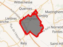 | |
) Linghem ) Linghem | |
| Coordinates: 50°35′41″N 2°22′18″E / 50.5947°N 2.3717°E | |
| Country | France |
| Region | Hauts-de-France |
| Department | Pas-de-Calais |
| Arrondissement | Béthune |
| Canton | Aire-sur-la-Lys |
| Intercommunality | CA Béthune-Bruay, Artois-Lys Romane |
| Government | |
| • Mayor (2008–2014) | Xavier Courouble |
| Area 1 | 3.63 km2 (1.40 sq mi) |
| Population (Jan. 2017)[1] | 205 |
| • Density | 56/km2 (150/sq mi) |
| Time zone | UTC+01:00 (CET) |
| • Summer (DST) | UTC+02:00 (CEST) |
| INSEE/Postal code | 62517 /62120 |
| Elevation | 36–80 m (118–262 ft) (avg. 48 m or 157 ft) |
| 1 French Land Register data, which excludes lakes, ponds, glaciers > 1 km2 (0.386 sq mi or 247 acres) and river estuaries. | |
Linghem is a commune in the Pas-de-Calais department in the Hauts-de-France region of France.
Geography
Linghem is situated about 12 miles (19.3 km) northwest of Béthune and 34 miles (54.7 km) west of Lille, on the D90 road. The A26 autoroute forms the western border of the commune.
Population
| Year | Pop. | ±% p.a. |
|---|---|---|
| 1968 | 263 | — |
| 1975 | 257 | −0.33% |
| 1982 | 224 | −1.94% |
| 1990 | 229 | +0.28% |
| 1999 | 230 | +0.05% |
| 2007 | 214 | −0.90% |
| 2012 | 214 | +0.00% |
| 2017 | 205 | −0.86% |
| Source: INSEE[2] | ||
Places of interest
- The church of St. Vaast, dating from the sixteenth century.
See also
References
- ^ "Populations légales 2017". INSEE. Retrieved 6 January 2020.
- ^ Population en historique depuis 1968, INSEE