La Jarrie | |
|---|---|
) Town hall | |
.svg.gif')) Coat of arms | |
Location of La Jarrie 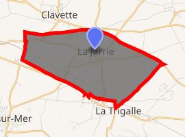 | |
) La Jarrie ) La Jarrie | |
| Coordinates: 46°07′45″N 1°00′31″W / 46.1292°N 1.0086°W | |
| Country | France |
| Region | Nouvelle-Aquitaine |
| Department | Charente-Maritime |
| Arrondissement | La Rochelle |
| Canton | La Jarrie |
| Intercommunality | CA La Rochelle |
| Government | |
| • Mayor (2008–2014) | David Baudon |
| Area 1 | 9.45 km2 (3.65 sq mi) |
| Population (Jan. 2017)[1] | 3,265 |
| • Density | 350/km2 (890/sq mi) |
| Time zone | UTC+01:00 (CET) |
| • Summer (DST) | UTC+02:00 (CEST) |
| INSEE/Postal code | 17194 /17220 |
| Elevation | 11–43 m (36–141 ft) (avg. 37 m or 121 ft) |
| 1 French Land Register data, which excludes lakes, ponds, glaciers > 1 km2 (0.386 sq mi or 247 acres) and river estuaries. | |
La Jarrie is a commune in the Charente-Maritime department in southwestern France.
Geography
The commune consists of the small town La Jarrie and parts of the hamlets Grolleau, Chassagné and Puyvineux.
Population
| Year | Pop. | ±% |
|---|---|---|
| 1962 | 997 | — |
| 1968 | 1,056 | +5.9% |
| 1975 | 1,596 | +51.1% |
| 1982 | 2,235 | +40.0% |
| 1990 | 2,413 | +8.0% |
| 1999 | 2,653 | +9.9% |
| 2008 | 2,780 | +4.8% |
See also
References
- ^ "Populations légales 2017". INSEE. Retrieved 6 January 2020.