| Khowai River | |
|---|---|
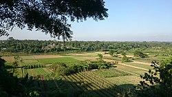
 Khowai River at Teliamura | |
| Native name | খোয়াই নদী |
| Location | |
| Countries | India and Bangladesh |
| State | Tripura |
| District | Habiganj |
| Physical characteristics | |
| Source | |
| • location | Atharamura Hills |
| Length | 166 km (103 mi) |
Khowai River is a trans-boundary river that originates in the eastern part of the Atharamura Hills of Tripura in India.
Geography
Flowing north-north-west, it leaves India at Khowai, and enters Bangladesh at Balla in Habiganj District. The river passes east of Habiganj town, where it is under pressure from encroachment and pollution. North of town it turns west, and joins the Kushiyara near Adampur in Lakhai Upazila, Kishoreganj District. The river is 166 km long. It is the second longest river of Tripura.[1][2][3]
See also
- List of rivers of Bangladesh
- List of rivers of India
- Rivers of India
References
- ^ Murshed, Md Mahbub (2012). "Khowai River". In Islam, Sirajul; Jamal, Ahmed A. (eds.). Banglapedia: National Encyclopedia of Bangladesh (Second ed.). Asiatic Society of Bangladesh.
- ^ "Tripura Geography for the preparation of TPSC examinations..." tripuraexam.in. Retrieved 29 October 2020.
- ^ "Save Khowai River from land grabbers". The Daily Star. 8 April 2014. Retrieved 13 May 2020.