| Kherlen River 克鲁伦河 (Kèlǔlún hé) | |
|---|---|
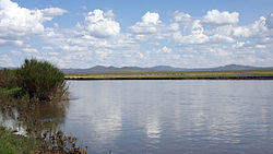
 Near Ondorkhaan | |
 | |
| Etymology | Mongolian: kherlen, "hederated" |
| Native name | Хэрлэн гол |
| Location | |
| Country | Mongolia, People's Republic of China |
| Mongolian Aimags | Khentii, Dornod |
| Chinese Region | Inner Mongolia |
| Chinese Prefecture | Hulunbuir |
| Physical characteristics | |
| Source | |
| • location | Burkhan Khaldun, Khentii Mountains |
| Mouth | Hulun Nuur |
• coordinates | 48°44′N 117°5′E / 48.733°N 117.083°E |
| Length | 1,254 km (779 mi) |
Kherlen River (also known as Kern or Kerülen; Mongolian: Хэрлэн гол; Chinese: 克鲁伦河; pinyin: Kèlǔlún hé) is a 1,254 km river in Mongolia and China.[1]
Course
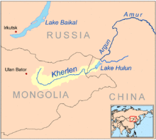
The river originates in the south slopes of the Khentii mountains, near the Burkhan Khaldun mountain in the Khan Khentii Strictly Protected Area, about 180 km northeast of Ulaanbaatar.[1] This area is the watershed between the arctic (Tuul River) and pacific (Kherlen, Onon) basins and named Three river basins.
From there the Kherlen flows in a mostly eastern direction through the Khentii aimag. On its further way it crosses the eastern Mongolian steppe past Ulaan Ereg and Choibalsan, entering China at 48°3′N 115°36′E / 48.050°N 115.600°E, emptying into Hulun Nuur after another 164 km.
Kherlen-Ergune-Amur
In years with high precipitation, the normally exitless Hulun Lake may overflow at its northern shore, and the water will meet the Ergune River after about 30 km.[1] The Ergune marks the border between Russia and China for about 944 km, until it meets the Amur River. The system Kherlen-Ergune-Amur has a total length of 5,052 km.
See also
- List of rivers of Mongolia
References
- ^ a b c Brutsaert, Wilfried; Sugita, Michiaki (December 2008). "Is Mongolia's groundwater increasing or decreasing? The case of the Kherlen River basin". Hydrological Sciences Journal. London: Taylor & Francis Informa Ltd. 53 (6): 1221–1229. doi:10.1623/hysj.53.6.1221. Retrieved 19 January 2015.