Jemaluang |
|---|
|
| Other transcription(s) |
|---|
| • Jawi | جيملواڠ |
|---|
| • Chinese | 三板头 / 任罗宏 |
|---|
 |
| Country | Malaysia |
|---|
| State | Johor |
|---|
| District | Mersing District |
|---|
| Area |
|---|
| • Total | 124 km2 (48 sq mi) |
|---|
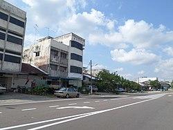
Jemaluang is a town and mukim in Mersing District, Johor, Malaysia.[1]
Geography
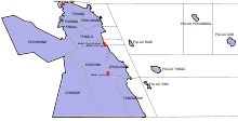
Jemaluang in Mersing District
Jemaluang lies on the intersection of national highway 3 and 50.
The mukim (commune) surrounding the town spans over an area of 124 km2 and also includes 10 nearby villages.[2]
Geology
The mukim also includes Belunak Island.[3] It is worth noting that Jemaluang is not located in mukim Jemaluang.
References
This article is copied from an
article on Wikipedia® - the free encyclopedia created and edited by its online user community. The text was not checked or edited by anyone on our staff. Although the vast majority of Wikipedia® encyclopedia articles provide accurate and timely information, please do not assume the accuracy of any particular article. This article is distributed under the terms of
GNU Free Documentation License.
All content on this website, including dictionary, thesaurus, literature, geography, and other reference data is for informational purposes only. This information should not be considered complete, up to date, and is not intended to be used in place of a visit, consultation, or advice of a legal, medical, or any other professional.
)
)