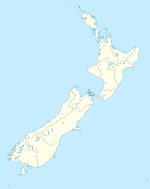
Himatangi is a small settlement in the Manawatū-Whanganui region of New Zealand's North Island. It is located at the junction of State Highways 1 and 56, 25 kilometres west of Palmerston North, and seven kilometres east of the coastal settlement of Himatangi Beach.
The area has two marae:
- Motuiti Marae and its Rakau or Paewai meeting house is affiliated with the Rangitāne hapū of Ngāti Mairehau and the Ngāti Raukawa hapū of Ngāti Rākau.
- Paranui Marae and its Turanga meeting house is affiliated with the Ngāti Raukawa hapū of Ngāti Te Au and Ngāti Tūranga.[1][2]
About 50 Māori land blocks are located between Himatangi and Foxton to the south.[3]
History
The area was largely undeveloped with rough terrain in 1942, according to a photograph held in the National Library of New Zealand.[4]
Himatangi was once the location of the junction between the New Zealand Railways Department's Foxton Branch railway and the Manawatu County Council's Sanson Tramway. Both lines are now closed; use of the Tramway ceased in 1945, followed by the Branch in 1959.
In 2005, a study found agricultural pesticides were being rapidly leached into the sandy soil at Himatangi.[5]
In 2009, planning approval was granted for the building of a piggery after the landowner agreed to reduce from what he originally proposed.[6]
In 2014, the community was used as a trial community for the Horizons Regional Council's emergency readiness plan. The landowner and New Zealand Pork Board had been considering legal action through the Environment Court.[7]
In 2019 a regional bus service between Levin and Palmerston North was introduced, providing a weekly return service between Himatangi and Foxton.[8]
Education
Oroua Downs School is a co-educational state primary school for Year 1 to 8 students,[9][10] with a roll of 116 as of March 2020.[11]
See also
- Himatangi Beach
References
- ^ "Te Kāhui Māngai directory". tkm.govt.nz. Te Puni Kōkiri.
- ^ "Māori Maps". maorimaps.com. Te Potiki National Trust.
- ^ "Visualising Māori Land – Himatangi". whenuaviz.landcareresearch.co.nz. Landcare New Zealand.
- ^ NZ Aerial Mapping Ltd. "Himitangi". natlib.govt.nz. National Library of New Zealand.
- ^ Close, Murray (January 2005). "Field study of pesticide leaching in a Himatangi sand (Manawatu) and in a Kiripaka bouldery clay loam (Northland)". Australian Journal of Soil Research. 43 (4).
- ^ "Green light for Himatangi piggery". Stuff. Manawatu Standard. 31 January 2009.
- ^ "Himatangi first up for community readiness". Horizons Regional Council. 24 February 2014.
- ^ "New off-peak bus services from Levin to Palmerston North". Horizons Regional Council.
- ^ "Oroua Downs School Official School Website". orouadowns.school.nz.
- ^ "Oroua Downs School Ministry of Education School Profile". educationcounts.govt.nz. Ministry of Education.
- ^ "Oroua Downs School Education Review Office Report". ero.govt.nz. Education Review Office.

